5. Food Systems in British Columbia
Case Study 1: The Agricultural Land Reserve (ALR)
The Agricultural Land Reserve (ALR) is a provincial land-use zone that recognizes agriculture as the priority use for approximately 4.6% of the land base of British Columbia (ALC, 2013). Established under the provincial Land Commission Act of 1973, the ALR is one of the earliest examples in North America using regional zoning laws to permanently preserve farmland and promote local food production.
The ALR is administered by the Agricultural Land Commission (ALC),[1] an independent administrative tribunal that currently consists of no less than seven appointed members including a chair and members representing six regional panels. The purpose of the ALC is to preserve agricultural land; to encourage farming on agricultural land in collaboration with other communities of interest; and to encourage local governments, First Nations, the government and its agents to enable and accommodate farm use of agricultural land and uses compatible with agriculture in their plans, bylaws and policies. The ALC reviews all applications for exclusion, inclusion, subdivision and non-farm use applications under the Agricultural Land Commission Act of 2002 and ALR regulations.
ALR regulations outright permit many farming activities such as raising livestock, creating greenhouses and producing poultry, dairy, horticultural plants, vegetables, grains and tree fruits. ALR regulations allow local governments to restrict but not prohibit other uses such as farm retail sales, storing, packing and processing, agroforestry, timber production, equestrian facilities and compost production. ALR regulations also outline permitted non-farm uses that can be prohibited by local governments such as agritourism accommodation, temporary saw mills, pet kennels and breeding facilities, education and research, and road construction with right-of-way.
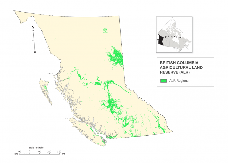
Geography of the ALR
When first delineated, the ALR was estimated to include 4,716,516 hectares. As of April 2013, the ALR includes approximately 4,621,700 hectares consisting of both private and Crown (federal and provincial) lands. The ALR is distributed over six administrative regions:
- North (2,210,783 hectares, 49%)
- Interior (1,528,968 hectares, 33%)
- Kootenay (392,557 hectares, 8%)
- Okanagan (224,977 hectares, 5%)
- South Coast (148,207 hectares, 3%)
- Island (116,207 hectares, 2%) (ALC 2013)
Establishing the ALR
Urban sprawl poses many challenges to agricultural land preservation and local food production, particularly in environments that have limited land suitable for agriculture. In BC, only 5% of the land base is considered suitable for agriculture and 2.7% capable of growing a reasonable range of crops (lands ranked as Class 1 through 4 by the Canadian Land Inventory) (Smith, 2012). Prime agricultural lands (1.1% of provincial land base) are often located in narrow valleys near densely populated urban areas and subject to heavy competition with other development uses.
It is estimated that in the early 1970s, up to 6,000 hectares of farmland was annually lost to urban sprawl (Smith, 2012). Increasing public awareness of the threat of urban sprawl to scarce farmland led directly to the creation of the ALR. In 1973, Minister of Resources Robert Williams championed a plan to pursue regional land use zoning as economically less costly than the purchase of development rights or agricultural lands outright (Petter, 1985).
By 1976, delineation was completed by the commission and 28 regional districts. ALR boundary delineation focused on including agricultural lands ranked as CLI Classes 1 to 4. In 1978, an audit found that approximately 53% of the lands in the ALR fell into these classes:
- Class 1 (1.1%)
- Class 2 (6.3%)
- Class 3 (15%)
- Class 4 (30.6%)
- Class 5 (31.9%)
- Class 6 (9.4%)
- Class 7 (3.6%)
- Water (1.9%)
The fact that there was more water (88,890 hectares) than Class 1 land (52,920 hectares) indicates the scarcity of prime agricultural lands in BC. Marginal lands were included in the ALR for several technical reasons. Some marginal lands were active agricultural lands (e.g., rangelands and land used for the production of cranberries or blueberries), and other marginal lands could not be spatially disaggregated without impacting higher class lands. The Canadian Land Inventory provided a rough estimate of field conditions (original map scales were at 1:50,000), and aligning existing legal boundaries for private properties with the distribution of high-quality lands was not feasible given the commission’s timeframe, mandate and resources.
In 1983, the creation of the Land Capability Classification System for Agriculture in British Columbia (which uses a similar classification scheme to the CLI) allowed the ALC to have more detailed estimates of agricultural potential of BC lands, though the CLI continues to be used in areas not covered by this more detailed analysis. Despite the emphasis on Class 1 to 4 lands in the creation of the ALR, these rankings are only one aspect of defining agricultural lands. When judging proposed changes to the ALR, the ALC examines the agricultural potential of the parcel and surrounding lands by looking at agriculture capability ratings in addition to factors related to productivity, yield and suitability.
Governance of the ALR
Since 1973, several legislative changes have impacted the administration of the ALR, though the central mission to permanently preserve agricultural lands has remained intact. In 1977, the ALC was relieved of the responsibility for land banks, greenbelts and parklands in order to focus attention on agricultural land preservation. In addition, public hearings were required for exclusion applications from regional districts and municipalities, and appeals to ALC decisions were to be made to Cabinet. In 1988, regulatory changes resulted in golf courses being classified as a permitted use of agricultural land, which resulted in 181 applications (120 of which moved forward). In the 1990s, changes included:
- A moratorium on golf course development
- Changes to the ALC decision appeal processes (requiring that Cabinet refer appeals to a board or commissioner)
- Implementation of a vague “provincial interest” clause that allowed Cabinet significant interpretative leeway and became a serious controversy in the 1999 Six Mile Ranch judgment
- The merging of the ALC with the Forest Land Commission
In 2002, the Agricultural Land Commission Act (ALCA) removed forestry land management duties from the ALC and reorganized the commission into a 19-person committee with a chair and six regional panels of three people each. In the ALC strategic plan for 2003, the ALC introduced the idea that exclusion of land from the ALR could be approved based on “community need” and “net benefit” to agriculture. Pro-ALR citizens and organizations like the Suzuki Foundation highlighted these new terms as a concern and challenged them as contravening the ALCA (Campbell, 2006).
Future of the ALR
In 2010, the BC Auditor General and ALC Chair Richard Bullock released complimentary reports that analyzed the ALC and ALR. These reports noted that despite funding challenges and legislative changes, the ALR had been largely successful in preserving agricultural lands. As well, they noted that the ALC required transformation and increased funding in order to meet its mandate and to continue to effectively administer the ALR.
In 2011, the provincial government made a one-time increase to the annual ALC budget and committed to $4 million in additional funding until 2015. In addition, the ALC began to undertake a ALR boundary review that would ensure:
- The ALR has defensible and accurate boundaries
- Updating of the technology required to undertake its legislated duties, including accurate GIS, electronic records that are publicly accessible and an online application portal
- A proactive long-term planning organization that works with local communities and places priority considerations on bona fide farmers and ranchers to identify and cooperatively address emerging issues, and to develop capacity to respond to and enforces against improper use of ALR
The success of this new emphasis to adequately resource and to move the ALC into a proactive tribunal engaged with planning will determine the future of the ALR and the ability of BC to maintain its agricultural lands for future generations.
Attributions
Figure 5.9 British Columbia Agricultural Land Reserve by Hilda Anggraeni. Map data from http://www.alc.gov.bc.ca/Mapping/gis_data.htm
- Agriculture Land Commission http://www.landcommission.gov.bc.ca ↵
