8. Physical Geography of British Columbia
Case Study 2: 1964 Port Alberni Tsunami
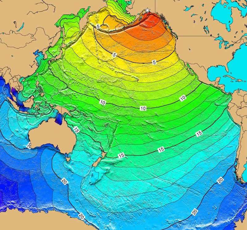
On the afternoon of Good Friday, March 27, 1964, the strongest earthquake recorded in North America, and the second strongest ever recorded, occurred in Alaska. The Great Alaskan Earthquake was a 9.2 magnitude subduction zone (megathrust) earthquake located at a depth of approximately 25 kilometres. It lasted four minutes and 38 seconds. 131 people died in the earthquake and ensuing tsunami’s (USGS, 2012).
The epicentre of the earthquake was 125 kilometres east of Anchorage, Alaska, where many inadequately engineered houses, buildings and infrastructure were damaged or destroyed. Three hundred kilometers southwest, some areas near Kodiak were permanently raised by 9.1 metres. Southeast of Anchorage, areas around the head of Turnagain Arm near Girdwood and Portage dropped as much as 2.4 metres. A massive underwater slide at Port Valdez in Prince William Sound created an 8.2 metre tsunami that destroyed the village of Chenega, killing 23 of the 68 people who lived there. Post-quake tsunamis severely affected Whittier, Seward, Kodiak and other Alaskan communities, as well as people and property in Oregon, California and British Columbia.
Two types of tsunami were produced as a result of the earthquake: a tectonic tsunami caused by the movement of the tectonic plates, and subaerial landslide (or submarine) tsunami caused by underwater landslides. About 20 of these smaller tsunamis were responsible for the majority of the tsunami damage in over 20 countries, including Canada, Peru, New Zealand, Papua New Guinea and Japan. The largest recorded wave was at Shoup Bay, Alaska, at height of about 67 metres.
Three hours after the quake, a 1.4 metre tsunami wave reached Prince Rupert, BC, and did little damage. Then, around midnight, the first of two waves began travelling up the 40 kilometre Alberni Inlet toward the towns of Alberni and Port Alberni. The narrow inlet amplified the size and intensity of the wave, and when it struck the two towns it had a height of 2.44 metres. One hour later, a second, larger wave of 3.05 metres hit. It was the second wave that caused most of the damage, lifting houses off their foundations and sweeping log booms on shore. The second wave was followed by four more waves ranging in height from 1.52 metres and 1.83 metres and ocurring at roughly 90 minute intervals.
In total, the tsunami washed away away 55 homes and damaged 375 others. It caused $5 million in damage in Port Alberni and Alberni. The mill at Port Alberni, which employed 4,000 people, was temporarily closed. Incredibly, there were no fatalities in either town. The tsunami lead directly to the amalgamation of Alberni and Port Alberni into a single town in 1966.
Animation of Tsunami Generated by the Earthquake
If you are reading this in print, you can see the animation at https://www.youtube.com/watch?v=rJOGJApz1M0.
Attributions
Figure 8.11 Calculated Travel Time Map for 1964 Alaska Tsunami (http://en.wikipedia.org/wiki/File:Calculated_Travel_Time_Map_for_1964_Alaska_Tsunami.jpg) by Ngdchazards used under CC BY SA 3.0 (http://creativecommons.org/licenses/by-sa/3.0/deed.en)
