8. Physical Geography of British Columbia
Geology
The term geology comes from the Greek words “ge” (“earth”) and “logia,” meaning the study of and discourse involving the solid Earth, including the rocks of which it is composed, and the processes by which those rocks change. Geology can also refer generally to the study of the solid features of any celestial body (such as the Moon or Mars). Geology gives insight into the history of the Earth by providing the primary evidence for plate tectonics, the evolutionary history of life and past climates.
In British Columbia, geology is important for economic development associated with mineral and hydrocarbon (oil and natural gas) exploration and harvest. Geology is valuable to the public for predicting and understanding natural hazards, the remediation of environmental problems, and for providing insights into past climate change. Geology also plays a role in geotechnical engineering and is a major academic discipline.
Formation of the mountains is a dramatic evolving process associated with geology and geomorphology. Geomorphology is the study of the process that creates and transforms the surface of the Earth. Geomorphology seeks to understand landform history and dynamics, and predicts changes through a combination of field observation, physical experiment and numerical modelling (geomorphometry).
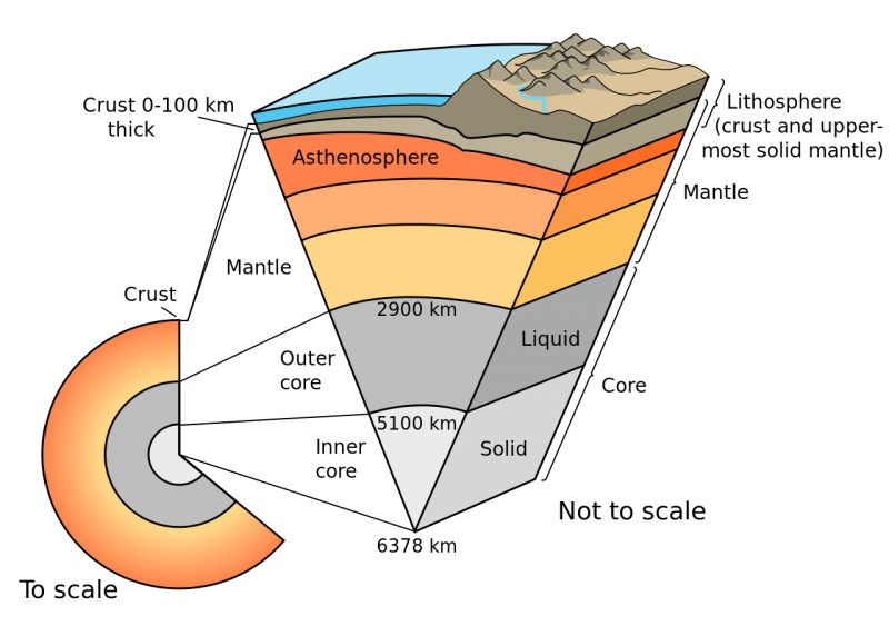
The Earth is stratified, meaning that it has several layers. In the very centre lies the solid core, which is surrounded by a liquid core. Next is the mantle, asthenosphere, the lithosphere and finally the crust at the top.

Each of these layers is made up of different mineral composition.
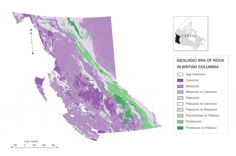
Several types of rocks are found throughout the crust. Plate tectonics theory suggests that the Earth’s lithosphere is made up of seven large plates and several small ones. Rising convection plumes from the asthenosphere can force the plates to move. The plate edges are where most volcanic and earthquake activity take place. These activities move minerals and materials. Below is a map of the geologic era rock found in British Columbia.

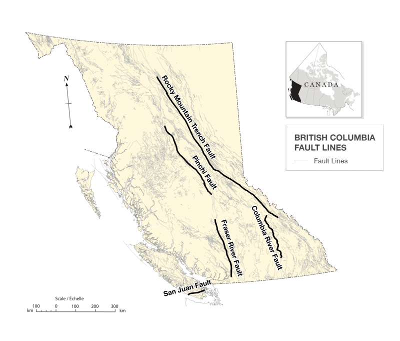
Plate tectonics is a significant field of study in BC since as there are so many fault lines (see Figure 8.8). Faults are where plates meet. When two plates jam together, the edges often fracture and collapse forming mountain ranges in a process called orogeny.
Another significant process to the formation of the rugged terrain found in BC is isostasy, which is the process of the surface of the Earth loading and unloading. For example, the Rocky Mountains are made up of sedimentary rock which erodes relatively quickly. A process is known as isostatic rebound, occurs which is the gradual rising of land elevations as it springs back after thousands of years of being crushed under the weight of continental glaciers.
A complex system of fault lines can be found in British Columbia. In Figure 8.8, all known and inferred fault lines are present with the major fault lines in bold. These fault lines have been designated as “major” because of their length and their potential impact on human populations. The five fault lines featured in the figure are the Pinchi Fault in Central BC, the Fraser River Fault, the Columbia River Fault, the Rocky Mountain Fault and the San Juan Fault.

Subduction
View a short video on subduction from the National Oceanographic and Atmospheric Administration at http://oceanexplorer.noaa.gov/edu/learning/player/lesson04.htmWhile the San Juan Fault may look small on this map, an earthquake along this fault could have significant ramifications for the residents of southwestern BC. The San Juan Fault separates the oceanic Juan de Fuca Plate from the heavier and denser North American continental plate through subduction. Subduction occurs when two plates collide and one is denser or heavier than the other, forcing the heavier one downward and under the other. Subduction can cause trenches in the ocean floor, which will warm and may cause the plate to melt, producing magma and flow into volcanic eruptions at the surface resulting in new rocks. These processes also move and transfer minerals and sediment from different layers of the Earth and deposit them in different places.
Understanding how and where these pieces of sediment have come from and moved to help geologists unlock the mystery of the formation of surface terrain. For example, the Pinchi Fault is a significant fault system in central BC that extends 450 kilometres and separates dominating oceanic sedimentary bedrock in the region from the volcanic rocks in the eastern portion of the province (Plouffe, 2001). The resulting terrain consists of a plate pushing up instead of down against the edge of the neighbouring plate, which can cause significant earthquakes.
Attributions
- Figure 8.6 Earth-cutaway-schematic-english Licensed under Public domain via Wikimedia Commons.
- Figure 8.7 Geologic era of rock in British Columbia. Created by Hilda Anggraeni with data provided by Digital Geology Maps BC Ministry of Geology and Mines (http://www.empr.gov.bc.ca/Mining/Geoscience/PublicationsCatalogue/DigitalGeologyMaps/Pages/default.aspx)
- Figure 8.8 British Columbia fault lines. Created by Hilda Anggraeni with data provided by Digital Geology Maps BC Ministry of Geology and Mines (http://www.empr.gov.bc.ca/Mining/Geoscience/PublicationsCatalogue/DigitalGeologyMaps/Pages/default.aspx)

