Chapter 7. British North America at Peace and at War (1763–1818)
7.6 Interwar Years: The Canadas
In 1791 the Constitutional Act replaced the Quebec Act and redefined the province’s boundaries. What had been the heartland of old Canada, stretching east from the Ottawa River’s junction with the St. Lawrence to the Gulf, became Lower Canada. Everything to the west became Upper Canada. Excluded from these borders were the 1.5 million acres to the north and west that drain into Hudson Bay and which remained under the control of the Hudson’s Bay Company. (See Chapter 8.)
Bisecting Canada
Britain had several goals in mind with the Constitutional Act. First was to establish consistency in administrative structure in each of the colonies of British North America, and the creation of the colonies of New Brunswick and Cape Breton in 1784 provided a template for this purpose. As well, there was a desire to create some consistency within the British Parliamentary system: the British were starting to conceive of their model as an idea that could be exported around the globe.
The second goal was to ensure the power of the executive over elected representatives, which in some measure contradicted the first goal. The governor’s powers were, in fact, to increase at the head of an appointed executive council. An elected legislative council could draft legislation and recommend action, but it was the executive (over which the governor ruled) that made the key decisions.
What Britain sought, then, was the form of parliamentary government (an elected assembly, a royal representative in council), but its function would be defined by its loyalty to the Crown. Clearly the events in the American colonies had an impact on this thinking: there would be less autonomy allowed to colonial governments, not more.
The third goal of the Constitutional Act was to cut imperial costs by making it possible for the local governments to raise funds for local projects. This seems a small thing, but in the context of mercantilism it represented a break with the policy of heavy dependence on the mother country. Having self-sustaining but beholden colonies was the new objective.
Finally, the drafters of the new constitution envisioned two separate cultures in the Canadas, one that was predominantly Catholic and francophone (Lower Canada), the other made up chiefly of anglophones and influenced strongly by the Church of England (Upper Canada). To that end, the Clergy Reserves were created in the Constitutional Act: one-seventh of all lands in Upper Canada were granted to the Anglican Church. Moreover, land in Upper Canada would be surveyed according to British land-use practices: in blocks rather than in the narrow seigneurial strips. Dividing the colony thus addressed religious differences in Canada and land-use issues as well. It also attended to the issue of civil law. Upper Canada would have British common law while Lower Canada would continue to use the Coutume de Paris where appropriate.
This provision for separate legal codes had an interesting impact on electoral regulations. In both colonies the vote was available to almost any adult over the age of 21 years who owned a rather modest amount of property. Even tenants in the towns could vote, providing they paid enough in rents to qualify. This made for a fairly broad franchise. Because of the peculiarities of property law in Lower Canada, however, it also meant that women could vote. While women in Upper Canada were sealed off from the franchise by British common law (which restricted their property rights), those barriers didn’t apply in Lower Canada. That fact, coupled with land title and inheritance laws that made a great many women property owners meant that for nearly 60 years some women in Lower Canada could vote.
The Constitutional Act would ultimately prove flawed. In less than a generation it was criticized for the way it favoured the Anglican elite in both colonies. Appointments to the executive councils were filled mostly by leading merchants and a sampling of the emergent local aristocracy, creating a pair of oligarchical governments. In Lower Canada this included many powerful anglophone merchants from Montreal who were, of course, a tiny but privileged ethnic and linguistic minority in the colony. In Upper Canada the council was dominated by military men, key Loyalists with wealth, and beginning in 1813, Bishop John Strachan (1778–1867). The 35-year-old Rector of York (later Toronto) was to become pivotal in building a tight network of elite leaders.
In Lower Canada the dominance of the anglophone-dominated executive was referred to disparagingly as the Chateau Clique, a reference to the fact that this tight little group met at and ran the colony from the governor’s residence. In Upper Canada the parallel term was Family Compact, but it was only coined in the 1820s. Both groups gained more authority after the War of 1812 when, for a while, the lustre was back on loyalism and Toryism.
Upper Canada
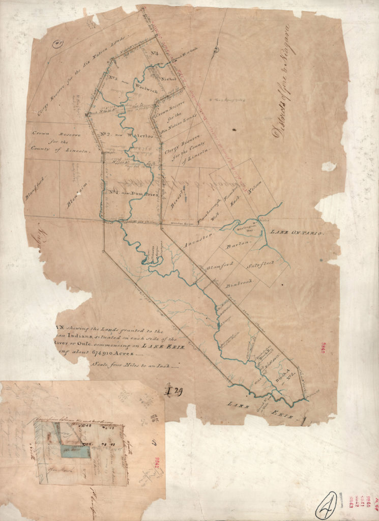
The period from 1784 to around 1818 can be described as one of readjustment and resettlement. Indigenous nations’ claims to territory in the region were more tenacious than ever, having lost so much south of the Great Lakes to the Americans. One branch of the Anishinaabeg (a.k.a. the Mississauga) sold a huge tract of land north of Lake Ontario so that the British could resettle non-Indigenous Loyalists. Further purchases were made north of Lake Erie along the Grand River to make way for the Loyalist Kanien’kehá:ka (Mohawk) (see Figure 7.15). Along with non-Indigenous Loyalists, the Kanien’kehá:ka were making their way across what is now upstate New York, heading for the Niagara Escarpment between Lakes Ontario and Lake Erie.
The map of Upper Canada became a patchwork of treaties — effectively bills of sale by which aboriginal title was extinguished. Often this was done in a hurry and details were not well addressed. Indigenous signatories focused on promises made verbally; British-Canadian officials would later emphasize what was (and wasn’t) written down. These arrangements were further compromised by uncertainty about annuities (annual payments by the British to the Anishinaabeg that look something like rents) as opposed to once-and-for-all purchase payments. No specific lands were set aside or “reserved” for Indigenous participants: there was thought to be sufficient unclaimed land to the west in Upper Canada so the Anishinaabeg quietly moved along to a different locale.
Upper Canadian society from 1783 to the 1820s has been characterized as one of intensifying settlement, land clearing, and organization. Keeping in mind that the territory was barely marked by French settlement before 1759 and that between 1763 and 1791 the British merely replaced the French in their forts and posts, little of the land had been cleared, and there was essentially no infrastructure. It has been noted that Upper Canada was the first British colony anywhere that lacked a seaport.[1] Whatever was produced in these years had to make it to the rapids at Lachine and from there, with some difficulty, to Montreal. Resolving the difficulties of shipping goods in and out of the colony occupied a central part of the political debates in Upper Canada for many years and continued after 1867 to inform political discourse in Canada.
The first Loyalist settlements in the colony were essentially engrossments around existing military positions. The Niagara frontier as well as the eastern end of Lake Ontario were both strategically important and convenient. Garrisons provided a market for farm surpluses as well as a sense of security in the event of further conflict (whether with the Americans or the Indigenous populations).
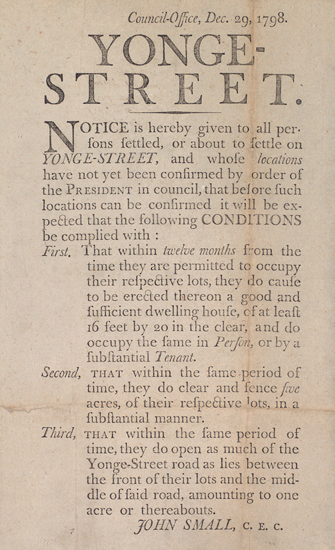
Settlement in Upper Canada was encouraged to 1820 by free land grants, but these were not allocated evenly. Officers in the British forces could claim as much as 5000 acres while just about everyone else received 200 acres. With the Clergy Reserves taking up valuable waterfront space and officers’ grants also occupying choice locations, typical settlers often had to head to less convenient or viable sites while the best land sat idle. And settlers were expected to achieve clear — if difficult — goals within a year of arriving, as can be seen in Figure 7.16.
Growth depended heavily on immigration and, perhaps ironically, much of that came from the United States. Claims to land across New York were made through the 1780s and 1790s with the effect that the best land was quickly spoken for. This obliged many American would-be farmers to become Canadian farming pioneers.
By 1800 the population of Upper Canada had grown from a few thousand to as much as 25,000, a significant number being Late Loyalists. To some extent the new farms could sell some of their surplus south of the border to nascent American settlements, but the goal for most at this stage was mere subsistence. What sustained many farm families in these days was British commitment to the colony. The Loyalists had earned support and the British government felt a moral obligation (and political pressure) to provide it. They had lost their homes and businesses and were waiting on compensation claims against the United States (most of which never came), and they needed defending. Britain provided direct subsidies and stimulated economic growth by maintaining garrisons throughout the colony.
One has to imagine the possible complexities of identity among some of the settlers in Upper Canada at this time. New York Patriots who fought against the British and drove terrified Loyalists from their homes in order to win lands in the Ohio Valley now moved into British North America and back under British rule. There they were neighbours to established United Empire Loyalist families and mostly dependent on the British garrisons to buy their farm surpluses. Joseph Brant’s Kanien’kehá:ka community might have scratched their collective heads as well: they had resisted (unsuccessfully) American expansionism, abandoned their ancestral lands and moved to the Grand River where a main source of wealth came from selling off parcels of their grant to American migrants.
The first generation of Upper Canadians was distinguished by their relative wealth coming into the colony. Some of the Late Loyalists who arrived across the New York–Niagara frontier into what is now southern Ontario were beneficiaries of land speculation. Some had started farms, which they then sold at a profit before heading west in search of free Canadian grants. Coupled to British subsidies, this was a cohort that started well, had a safety net of sorts, and had an artificial local market in the garrisons; they would turn to wheat as their principal cash crop. The Napoleonic Wars created new demand for wheat from the colonies so Upper Canadians (and some Maritimers) did well by this. Also, there appeared early on in the Canadas the means of adding value to grain and preserving it for later consumption by brewing. John Molson opened his first brewery in Montreal in 1786 and, thanks largely to thirsty garrison troops in the Canadas, he quickly amassed a fortune. Other brewers and distillers appeared across the Upper Canadian landscape in the decades to come, particularly around the area of London and York (Toronto).
The principal model of economic and social organization in these years was the family farm. This resulted in the arrival of Euro-Canadian children and, almost immediately, concerns regarding education. As historian Jane Errington has observed, these events coincided with a growing concern in the English-speaking world regarding the role of women in domestic settings, in towns, and in the nurturing of knowledge in children. Restrictively domestic notions of womanhood worked for a while against the education of girls but soon went by the wayside, while at the same time women struggled to secure teaching jobs before the War of 1812. Universal education of some kind for boys and girls was an accepted principle by the first years of the 19th century in Upper Canada and the size and sophistication of the local school came to be a measure of local progress.[2] Some of these schools were private operations and thus a source of currency in an economy where cash was not always easy to come by. (For a further discussion of education initiatives, see Chapter 10 and Chapter 12.)
Lower Canada
The American Revolution confirmed Quebec’s status as a British province. This occurred in two ways. First, there was the lack of interest shown by the Canadiens who might have joined or at least supported more vigorously the cause of the Continental Army. Second, although France in 1778 joined the Thirteen Colonies in their fight against the British, they played no role at the treaty table, and there was no hope of restoring Canada to France. Denied that possibility, the Canadiens found themselves cut off from the Ohio as well by the Treaty of Paris (1783). The Constitutional Act (1791) did further territorial damage by restricting Lower Canada to the St. Lawrence Valley.
Montreal’s role changed as well. It was no longer attached to its hinterland, much of which was now being administered by a separate colonial regime in Upper Canada (although that would prove to matter very little in practical terms). And with the Constitutional Act, Montreal’s British merchant elite lost the possibility of establishing an anglophone-Protestant population capable of shifting the cultural balance of power in the Province of Quebec. Île de Montreal was once again an island of English-speakers in a francophone colony. However, the border between Upper and Lower Canada took time to firm up. Loyalists settled most heavily in and around the Bay of Quinte, establishing the town of Kingston. These communities depended heavily on Montreal as their cultural and commercial metropolis and continued to do so for decades.
Like the Maritime colonies, Lower Canada benefited somewhat from the post-Revolutionary War boom in British shipbuilding and shipping. As the most mature of the agricultural economies still under British control, Lower Canada fed many of the newer settlements to the east and to the west. This was reflected in substantial population growth, almost all of which came from natural increase. The crude birth rate (CBR) in the towns (Montreal, Trois-Rivières, and Quebec) rose from 22.1 per 1000 women (aged 15 to 45) in 1790 to a high of 37.5 in 1811, falling a bit then surging to 43.8 in 1818. The rural CBR was vastly greater, rising from 47.5 per 1000 in 1790 to the mid-50s through most of the period, with peaks of about 56 in both 1795 and 1818. The growth of towns was significant but not staggering. The number of town-dwellers rose from 32,000 in 1786 to 41,042 in 1818. The countryside, however, more than doubled in size in the same years from 114,502 individuals to 283,433.[3]
A nagging problem in Lower Canada, one that would only get worse, was the availability of land. One reason for moving the Loyalists west was the difficulties entailed in fitting them into the seigneurial landscape. British and British American settlers wanted to be freeholders, not tenant farmers of any kind (another provision of the Constitutional Act). What’s more, the best riverfront land was already spoken for. From the perspective of the habitants, too, there were limits. Successive generations had carved the farms into less and less viable lots. Generations were parting ways as sons and daughters sought land in other parts of the colony. Further, operating costs were rising: even before the Seven Years’ War observers commented on how the Canadiens had cleared the forest far back from the river, using the wood for construction, fencing, and fuel. The effect was dramatic: by 1791 there was hardly a tree within a kilometre of the St. Lawrence. The amount of labour and money that had to be set aside for building materials and fuel rose, all of which had to be transported farther from forest to farm.
This clear-cutting of the valley had other ramifications. Habitat changes reduced the number of forest birds and thus increased the population of mosquitos. Wildlife generally was depleted and wildfowl in particular. The Canadien diet became less reliant on game and more on domesticated animals for protein. This, of course, required reassigning crop resources as feed or fields for grazing rather than for sale or the production of cash crops.[4] Historian Colin Coates has found evidence of marginal farm incomes in an interesting change in social behaviour. Coates observed a spike (from about 1800) in requests that clergy permit marriages between cousins. He argues that this arose because poorer families sought tighter internal alliances in order to better deflect loss of land and resources to people outside the extended family. Alternatively, Coates proposes that cousin-cousine marriages were a sign that the pool of possible marriage partners was shrinking as newcomers to seigneuries were kept away by the lack of available land.[5]
The colonial economy also began to change around 1800. The fur trade through Montreal was increasingly challenged in the West by the Hudson’s Bay Company, adding some uncertainty to its future. As is described in Chapter 8, turmoil and outright fur trade warfare had an impact on lives in the West; it also impacted fortunes in Lower Canada. Secondly, the timber trade in all of the colonies was stimulated by the Napoleonic Wars, which had the effect of redirecting Canadien labour from farms to forests. This produced some wealth and helped household incomes in the seigneuries as well, but it created new problems and patterns in its own right. Finally, the British market at last accepted grain from British North America and the United States, and a new market thus appeared overnight in the 1790s for farm surpluses.[6] This marked a significant opportunity for growers and shippers of Canadian farm produce, although it also brought with it increased dependency on the British marketplace and a reorientation away from markets as distant as the Mediterranean.
Key Takeaways
- The Constitutional Act created the colonies of Upper and Lower Canada and established conditions for executive and oligarchical rule.
- The constitution was the subject of criticism from about 1800 on.
- Upper Canada grew rapidly from a core group of Loyalists to which were added Indigenous and American migrants as well as British immigrants.
- The farming frontier in Upper Canada was a source of wealth attributable to farm output and the sale of lands.
- Population increases by natural means in Lower Canada placed pressure on the landscape.
Long descriptions
Figure 7.15 long description: Land survey of Six Nations land, completed in 1821. Featured in this survey is the Grand River, which is west of Lake Ontario in southern Ontario. Named but not depicted is Lake Erie, south of the river. A label running alongside the map reads “Districts of Gore and Niagara.”
Along the banks of the river are neatly divided parcels of land. Near the northern part of the river are a clergy and Crown reserve each for Six Nation lands and the County of Lincoln.
Several of the parcels of land along the river are numbered and named. From north to south, these numbers and names are Number 4, Nichol; Number 3, Woolwich; Number 2, Waterloo; Number 1, Dumfries. Then there is a considerable length of land that contains small riverbank settlements for the Cayugas, Mohawks, Aqugas, the Delawares and the Onandagas, among others; then there is Block B; and finally, just north of Lake Erie, there is Block A or Number 5.
East and west of the Grand River are square land parcels, presumably for settlers. These land parcels are named such things as Blandford, Blenheim, Beverly, Ancaster, Glanford, Saltfleet, and Barton.
Figure 7.16 long description: Notice from Council-Office, dated December 29, 1798. Titled “Yonge-Street.”
It reads, “Notice is hereby given to all persons settled, or about to settle on Yonge-Street, and whose locations have not yet been confirmed by order of the President in council, that before such locations can be confirmed it will be expected that the following CONDITIONS be complied with:
- That within twelve months from the time they are permitted to occupy their respective lots, they do cause to be erected thereon a good and sufficient dwelling house, of at least 16 feet by 20 in the clear, and do occupy the frame in Person, or by a substantial Tenant.
- That within the same period of time, they do clear and fence five acres, of their respective lots, in a substantial manner.
- That within the same period of time, they do open as much of the Yonge-Street road as lies between the front of their lots and the middle of said road, amounting to one acre or thereabouts.”
Notice is signed John Small, C.E.C.
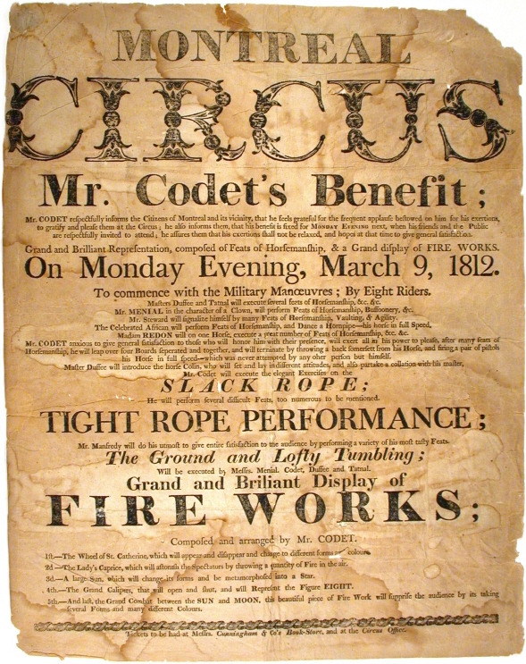
Figure 7.17 long description: Notice from the Montreal Circus about Mr. Codet’s Benefit.
It reads, “Mr. Codet respectfully informs the Citizens of Montreal and its vicinity, that he feels grateful for the frequent applause bestowed on him for his exertions, to gratify and please them at the Circus; he also informs them, that his benefit is fixed for Monday Evening next, when his friends and the Public are respectfully invited to attend; he assures them that his exertions shall not be relaxed, and hopes at that time to give general satisfaction.”
The notice promises “Grand and Brilliant Representation, composed of Feats of Horsemanship, & a Grand display of Fire Works” on Monday evening, March 9, 1812.
The evening is detailed as such (transcribed verbatim):
- To commence with the Military Manoeuvres; By Eight Riders.
- Masters Duffee and Tatmal will execute several feats of Horsemanship, etc., etc.
- Mr. Menial in the character of a Clown, will perform Feats of Horsemanship, Buffoonery, etc.
- Mr. Steward will signalize himself by many Feats of Horsemanship, Vaulting, & Agility.
- The Celebrated African will perform Feats of Horsemanship, and Dance a Hornpipe—his horse in full Speed.
- Madam Redon will on one Horse, execute a great number of Feats of Horsemanship, etc., etc.
- Mr. Codet, anxious to give general satisfaction to those who will honor him with their presence, will exert all in his power to please, after many feats of Horsemanship, he will leap over four Boards separated and together, and will terminate by throwing a back somerset from his Horse, and firing a pair of pistols, his Horse in full speed—which was never attempted by any other person but himself.
- Master Duffee will introduce the horse Collin, who will set and lay in different attitudes, and also partake a collation with his master.
- Mr. Codet will execute the elegant Exercises on the slack rope; he will perform several difficult Feats, too numerous to be mentioned.
- Tight rope performance; Mr. Manfredy will do his utmost to give entire satisfaction to the audience by performing a variety of his most tasty Feats.
- The Ground and Lofty Tumbling; will be executed by Messrs. Menial, Codet, Duffee and Tatmal.
Also featured will be a “Grand and Brilliant Display of Fire Works; composed and arranged by Mr. Codet,” the program for which follows:
- The Wheel of St. Catherine, which will appear and disappear and change to different forms and colours.
- The Lady’s Caprice, which will [astonish?] the Spectators by throwing a quantity of Fire in the air.
- A large Sun, which will change its forms and be metamorphosed into a Star.
- The Grand Calipers, that will open and shut, and will Represent the Figure Eight.
- And last, the Grand Combat between the Sun and Moon, this beautiful piece of Fire Work will supprise [sic] the audience by its taking several Forms and many different Colours.
Tickets to be had at Messrs. Cunningham and Co’s Book-Store, and at the Circus Office.
Media Attributions
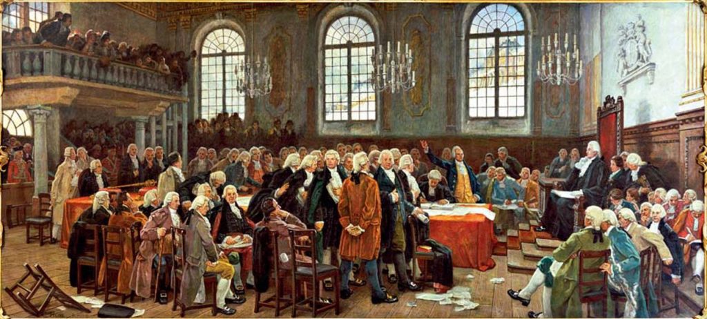
- Débat sur les langues lors de la première Assemblée législative du Bas-Canada le 21 janvier 1793 © c. 1910 by Charles Huot is licensed under a Public Domain license
- Map of Grand River Indian Lands © 1821 by Thomas Ridout is licensed under a Public Domain license
- Notice to settlers on Yonge-Street © 1798 by John Small is licensed under a Public Domain license
- Mr. Codet’s Benefit © 1812 by Montreal Circus is licensed under a Public Domain license
- Kenneth Norrie and Douglas Owram, A History of the Canadian Economy (Toronto: Harcourt Brace Jovanovich, 1991), 162. ↵
- Jane Errington, “Ladies and Schoolmistresses: Educating Women in Early Nineteenth-Century Upper Canada,” Historical Studies in Education 6, issue 1 (1994): 71–96. ↵
- T.J.A. Le Goff, “The Agricultural Crisis in Lower Canada, 1802–12: A Review of a Controversy,” in Perspectives on Canadian Economic History, ed. Douglas McCalla (Toronto: Copp Clark Pitman, 1987), 25, 32. ↵
- Colin M. Coates, The Metamorphoses of Landscape and Community in Early Quebec (Montreal & Kingston: McGill–Queen's University Press, 2000), 32–41. ↵
- Ibid., 67–68. ↵
- T. J. A. Le Goff, “The Agricultural Crisis in Lower Canada, 1802–12: A Review of a Controversy,” in Perspectives on Canadian Economic History, ed. Douglas McCalla (Toronto: Copp Clark Pitman, 1987), 10. ↵
The 1791 legislation that created two colonies — Upper and Lower Canada — out of what was left of the Province of Quebec after the Treaty of Paris (1783). In Upper Canada, the British common law was applied, while the Coutume de Paris survived in Lower Canada. Both colonies received their own administrative structures.
Created by the Constitutional Act (1791), land parcels set aside (one-seventh of all public lands) in Upper Canada for the use of the Church of England (a.k.a. Anglican Church). There were smaller Clergy Reserves in Lower Canada as well.
The ability and right to vote in a democratic society. It is always arbitrarily determined and is defined as much by who it excludes as by who it includes. “Universal adult male suffrage” was never achieved in British North America before Confederation, forget the extension of the franchise to women or Indigenous peoples generally.
The Chateau Clique were a highly influential cadre of economic and social leaders who fashioned themselves politically as the British (or Tory) Party in Lower Canada. Their numbers included prominent merchants like James McGill and John Molson. Their agenda included assimilation of the French Catholic population and perpetuating a hierarchical social and political order.
An association of leading individuals and families in Upper Canada devoted to the suppression of republican tendencies in the colony and perpetuating an oligarchy in government.
American immigrants who arrived in British North America in the years after the Revolution, especially in the 1790s and the first decade of the 19th century. Their “loyalism” was never certain, and they were often outspoken critics of Toryism.
An honorific title taken by Loyalists and their descendants to celebrate their migration to British North America at the end of the Revolution. Typically signals a strong Tory bent.
A series of wars involving France and much of the rest of Europe from 1803 to 1815. The War of 1812 was a chapter in the larger conflict.
The production of beer, like the distilling of whisky, was a means of adding value to surplus grain being grown in Upper and Lower Canada beginning in the 1780s. John Molson of Montreal was an early participant in brewing and — like many Canadians who followed in his footsteps in the liquor production trade — amassed a great fortune.
