Chapter 6. Intercolonial Rivalries, Imperial Ambitions, and the Conquest
6.7 Triangular Trade
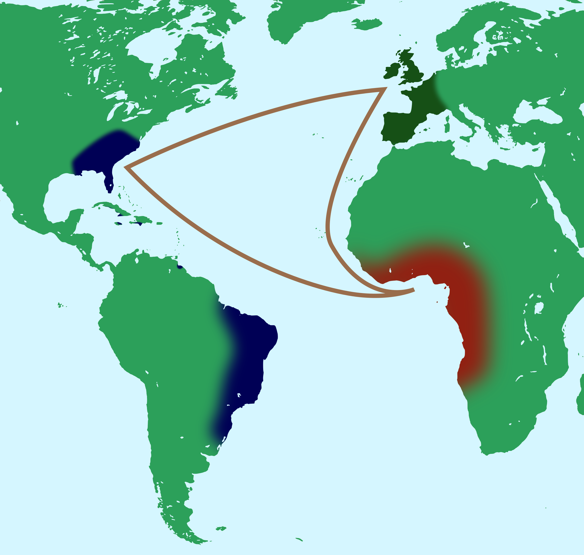
Both the French and the English colonies participated in what came to be known as triangular trade. This involved sending goods by sailing ships from Europe to Africa, buying slaves who were then transported across the Atlantic to the plantation colonies of the West Indies, loading up on products like sugar and tobacco, taking those north to the North American colonies where some trade took place before heading on home to Europe. This, at least, was the general idea behind the model of trade developed under the mercantilist system that dominated in all of the colonies. Certainly seaborne trade in these centuries depended entirely on trade winds that circulated the Atlantic in this clockwise direction.
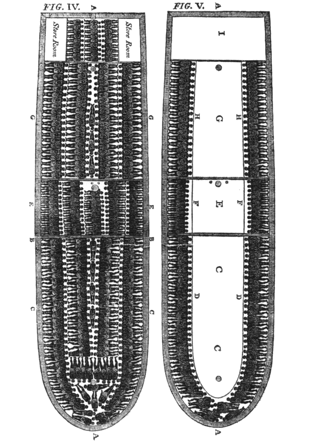
The trade winds that blew from Africa to the Caribbean made the Middle Passage of the slave trade a possibility. The Gulf Stream that runs from the Caribbean along the east coast of North America and curves along Nova Scotia’s southern flank and over the Grand Banks of Newfoundland was critically important to the economy of the region. It made the movement of goods like sugar and molasses from West Indian plantation colonies to distillers in ports like Boston and St. John’s a possibility. The predictability of shipping routes also made piracy on the east coast an attractive prospect. The Gulf Stream, too, ensured warm ocean waters and contributed significantly to the health of the fisheries in the region.
In practice, the triangular trade was almost always foreshortened. Ships suitable for carrying humans packed together for the lethal Middle Passage were not built to carry cash crops as well. Instead of cycling north they would work their way south of the equator where the winds would take them back to Africa for more human cargo. Similarly, fishing and whaling vessels such as those that formed the Portuguese and Basque fleets were able to strike out across the Atlantic from the Azores and head straight to the Grand Banks, cruising back to Europe along the Gulf Stream. English colonial traders tacked against the prevailing winds to the West Indies where they traded timbers and textiles into a market that was meant to be fully controlled by merchants in England.[1]
Acadians similarly bucked the currents to reach New England ports where they had trade contacts and even political allies. The broadest pattern of trade, however, and certainly the flow of capital that made the colonial system function as it did, adhered to the triangular pattern — even if the individual ship’s captains did not. Colonial success was often determined by geography: stopping points along these major routes significantly affected economies. Wealth and influence accumulated fastest in the African kingdoms along the Bight of Benin, on the largest and most easily reached Caribbean islands, in spacious and safe ports like New York, Providence, Boston, Halifax, and St. John’s, and in protected European centres of merchant power like Bristol, Liverpool, Nantes, Honfleur, and St. Malo. Isolation from this important corridor largely explains the decline of England’s east coast port cities (like Norwich) and the relatively slow growth of the economy of the St. Lawrence (as well as that of Île Saint-Jean). The French colonies in Canada did, however, have another asset, which is explored in the next chapter.
Key Takeaways
- The North American colonies were all part of a trade network that connected three, sometimes four continents.
- The structure of sea travel encouraged the growth of the slave trade and, thus, enabled plantation economies to exploit that model of labour.
Long descriptions
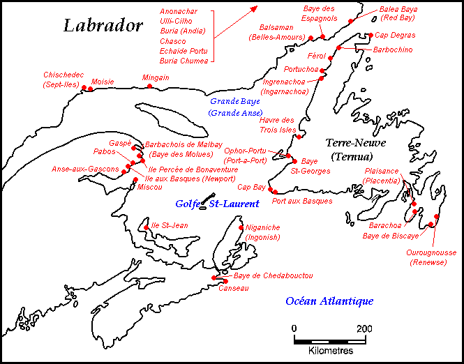
Figure 6.5 long description: Map showing Basque fisheries in the Gulf of St. Lawrence. Fisheries were concentrated along the northeastern shore of Nova Scotia, the Gaspé Peninsula in Quebec, the southeastern shore of Quebec and Labrador, and all around the shores of Newfoundland.
Media Attributions
- Triangular trade © 2011 by Hogweard is licensed under a CC BY-SA (Attribution ShareAlike) license
- Slave ship diagram © 1790 by unknown is licensed under a Public Domain license
- Basques fisheries © 2008 by Zorion is licensed under a CC BY-SA (Attribution ShareAlike) license
- Kenneth Morgan, Bristol and the Atlantic Trade in the Eighteenth Century (Cambridge: Cambridge University Press, 1993). ↵
Shipping lanes between Africa and the Americas on which the principal cargo was captive humans, enslaved in west Africa. Mortality rates were as high as 20% on the voyage.
A strong current that runs from the Caribbean along the east coast of North America, across the Atlantic, and along northwestern Europe. It accelerates sea traffic heading east to Europe and can impede vessels heading west to the Americas.
