Lab 17: BC’s Geology and Geologic Structures
Saoirse MacKinnon; Fes de Scally; and Todd Redding
Geomorphology is the scientific study of the characteristics and origins of landforms. Landforms arise through the interplay between endogenic processes fueled by Earth’s internal energy and exogenic processes ultimately fueled by the Sun. Endogenic processes tend to be responsible for the rock types and geological structures found in any particular area. Where geological structure dominates the surface landforms, they are called structural landforms and are the main focus of this lab.
This lab will provide experience in identifying and analyzing rock samples, identifying tectonic plate boundaries, interpreting geologic maps and cross-sections, and interpreting British Columbia’s (BCs) geologic history and rocks from the various geologic belts that span the province.
Learning Objectives
After completion of this lab, you will be able to
- Distinguish between the three major classes of rocks.
- Understand the basic terminology relating to geological structures.
- Identify different types of tectonic plate boundaries.
- Interpret geological maps and cross sections.
- Analyze rocks from across the province of British Columbia, and predict which geologic belt the rock samples were obtained from.
Pre-Readings
Classification of Rocks: Igneous, Sedimentary and Metamorphic
Rocks can be classified into three main categories: igneous, sedimentary, and metamorphic.
Igneous Rocks
Igneous rocks form from the cooling and crystallization of magma. Igneous rocks are divided depending on the environment in which the magma cooled:
- Intrusive igneous or plutonic (named after Pluto, the god of the underworld in Roman mythology) rocks form from magma that cooled deep underground. Because the magma in this case cools very slowly, intrusive igneous rocks usually contain relatively large mineral crystals. Common examples include granite, granodiorite, diorite and gabbro.
- Extrusive igneous or volcanic rocks form from magma in volcanic eruptions. Magma is called lava once it reaches Earth’s surface. Because in this case the magma cools quickly on Earth’s surface, the mineral crystals in the rock are either very small or non-existent. In situations where the lava cools very quickly, a volcanic glass called obsidian is produced. Common examples of extrusive igneous rock include basalt, dacite, andesite and rhyolite.
The precise type of intrusive or extrusive rock that is produced from cooling magma is determined by the magma’s chemical composition, especially the abundance of silica (SiO2). The silica content plays an important role in the physical characteristics of an igneous rock, including its resistance to weathering and erosion. It also plays an important role in the explosiveness of volcanic eruptions, because magma with a higher silica content is stickier and therefore more likely to produce an explosive eruption.
Sedimentary Rocks
Sedimentary rocks are formed by the lithification (compaction, cementation and hardening) of weathering and erosion products which have accumulated in a fluvial, marine or lacustrine environment over long periods of time. These products can be of two basic types, which provides us with a sub-classification of sedimentary rocks:
- Clastic sedimentary rocks are made from ground-down rock as well as other surviving minerals. Common examples include sandstone, conglomerate, siltstone or mudstone, and shale. Clastic sedimentary rocks exhibit a huge variation in their resistance to weathering and erosion depending on the degree of lithification of the clastic sediments they are composed of.
- Carbonate or chemical sedimentary rocks are made from the precipitation of minerals, primarily calcium carbonate, dissolved in water. Common examples are limestone (CaCO3) and dolomite (CaMg(CO3)2).
Metamorphic Rocks
Metamorphic rocks are formed by the alteration or partial melting of a sedimentary, igneous or pre-existing metamorphic rock by heat and pressure beneath Earth’s surface. Common examples include gneiss, marble, slate, schist and quartzite.
The specific type of metamorphic rock in question is largely a function of the original (or parent rock). For example, shale (a sedimentary rock) typically metamorphoses into slate, and granite (an intrusive igneous rock) typically metamorphoses into gneiss.
The type of metamorphic rock also depends on the degree of cooking that has occurred during the process of metamorphism. Foliated rocks result when the constituent minerals in the parent rock have been realigned into planar surfaces during metamorphism. Non-foliated rocks do not develop these planar fabrics.
Some metamorphic rocks can be more compact compared to their parent rock. Quartzite, for example, is much more resistant to weathering and erosion than its parent rock sandstone. In other cases, metamorphism creates planes of weakness within the rock, such as the foliation in gneiss.
Tectonic Plate Boundaries
The theory of plate tectonics provides the model that underlies our understanding of modern geology and the interactions between oceans and continents. Plate tectonics explains why the highest and lowest points on Earth occur where they do. Plate tectonics also explains why and where we can observe highly deformed rocks at or near the surface. The deformation is seen in the form of geologic features such as folds and faults.
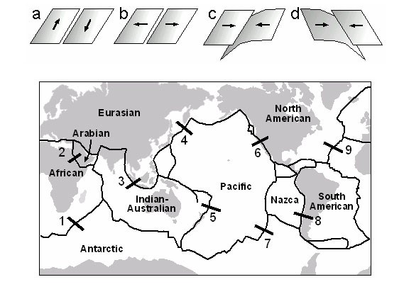
The type of plate boundary determines the types of deformation that may occur. Transform, or strike-slip plate boundaries occur when two plates move along each other in a predominately horizontal motion (scenario a in Figure 17.1). Divergent plate boundaries occur when two plates move away from each other (scenario b). Convergent plate boundaries occur when two plates move toward each other, or collide together (scenarios c and d).
Geologic Structures
Geological structure can be defined as the arrangement and attitude of rocks in Earth’s lithosphere. Structure results from tectonism, the deformation of Earth’s crust by endogenic forces. Tectonism includes both diastrophism, large-scale deformations of the crust producing mountain ranges, ocean basins, etc., and volcanism, the creation of crustal material on a more localized scale through volcanic activity. Both sets of processes are a result of the mechanism of plate tectonics.
Geological structures can be relatively simple if tectonic forces have not deformed the crust to any great degree. Examples include the horizontal beds of young sedimentary rocks which underlie much of the Prairie provinces of Canada. On the other hand, where deformation has been substantial, the resulting geological structure can be extremely complicated. Examples include the intensely deformed sedimentary and metamorphic rocks of many of BC’s mountain ranges or the Himalaya of South Asia.
Tectonism can produce a wide variety of geological structures including folds (flexures or bends in the crustal rocks due to compressional forces), and faults (brittle ruptures or fractures in the crustal rocks). Note that folding rarely involves rupturing of the rock, but faulting does.
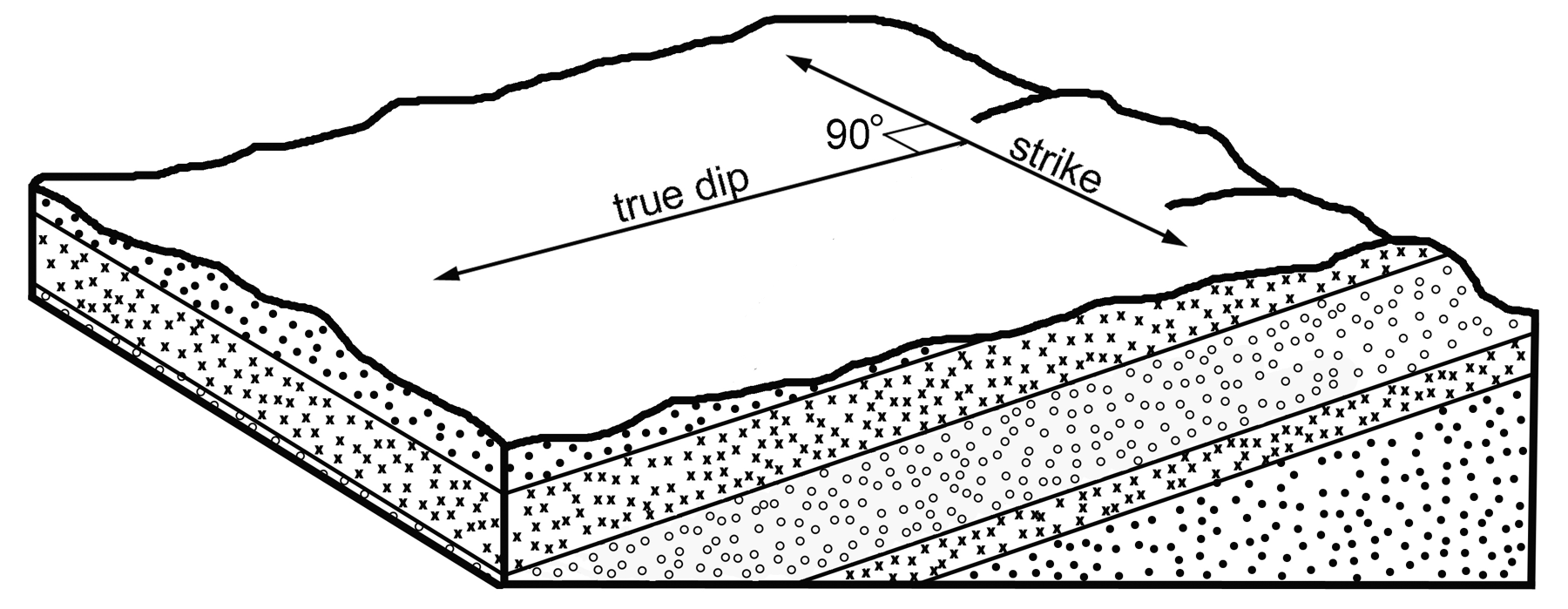
Folding and faulting impose two types of attitudes on the rock. Dip is the angle (measured in degrees) which the rock strata (layers, fault or any planar feature) make with a horizontal plane, measured in a direction perpendicular to the strike of the rock strata (Figure 17.2). Strike is the intersection between the plane in question and the horizontal plane. It is commonly expressed using the cardinal directions of the compass or as a full-circle azimuth.
Geologic History of British Columbia
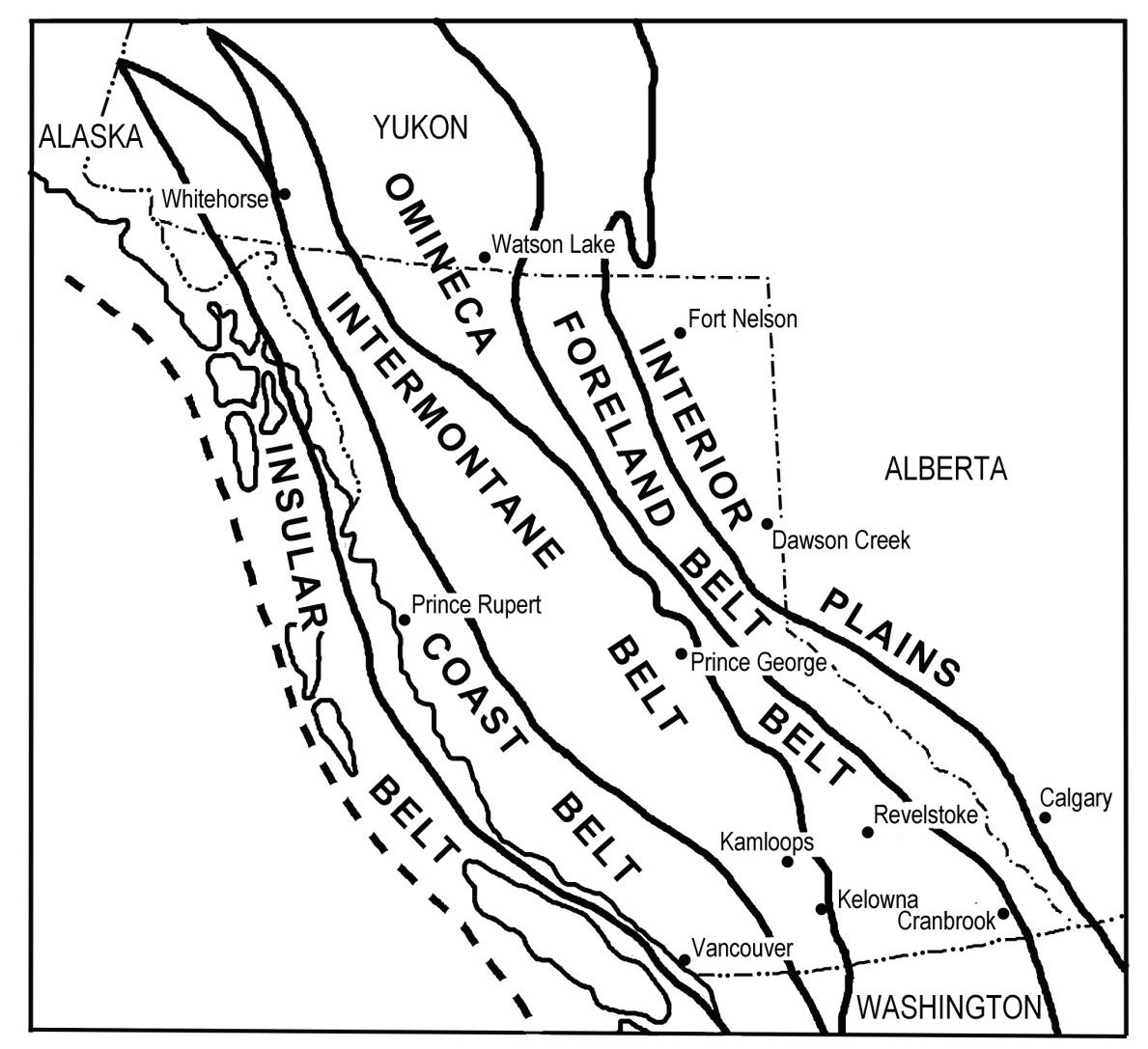
The geologic history of BC dates back to a time when there was actually no BC west of today’s Rocky Mountains. The western edge of the ancestral North American continent, composed of the ancient plutonic rocks of the North American craton (continental core), was situated roughly where Calgary and Dawson Creek are located today (Figure 17.3). West of this ancient shoreline, the submarine continental shelf extended roughly to where the town of Golden is situated today (just east of Revelstoke in Figure 17.3).
The following sections describe important intervals in BC’s geologic history. Some of this information is derived from British Columbia: A Natural History (Cannings and Cannings, 2004). Note that Ga = billion years, Ma = million years, a terrane is a fragment of crust formed on, or broken off of, a tectonic plate and added to crust on a different plate, and a superterrane is a group of related terranes.
1.7 Ga to 180 Ma
Over an immense time period of about 1.5 billion years, sediment eroded from the ancient North American craton is deposited in a miogeocline (a part of the submarine continental shelf along a tectonically quiescent continental margin where sediment deposition occurs) just offshore of the western margin of ancestral North America.
Although this continental margin formed a part of different supercontinents at various times over this period, including Rodinia and Pangaea, it was tectonically quiescent. This allowed uninterrupted sediment deposition in the miogeocline. Both clastic sediments (muds and sands) and carbonate sediments (from coralline organisms) were deposited, which has important implications for the formation of the Foreland Belt much later.
750-300 Ma
The supercontinent Rodinia broke up and another supercontinent Pangaea began to assemble. The wedge of sediment in the miogeocline offshore of ancestral North America continued to build and was eventually lithified into sedimentary rock. This included the burial of marine organisms around 530 Ma which today form the world-famous Burgess Shale fossil beds in Yoho National Park of BC.
245 Ma
The supercontinent Pangaea began to break up. Earth’s tectonic plates began their slow movement into their modern configuration.
200 Ma
Up to 2,000 km away in the ancestral Pacific Ocean, at an old plate boundary, the Intermontane superterrane began to assemble when the Stikinia and Quesnellia terranes (volcanic island arcs) were amalgamated with the sea floor sediments of the Cache Creek and Slide Mountain terranes. This produced a mélange (mix) of sea-floor sedimentary rocks and volcanic rocks.
180-150 Ma
A change in the direction of plate movement caused the ancestral North American continent to collide with the Intermontane superterrane. The tremendous heat and pressure of this slow-motion collision caused rocks of the miogeocline and the Intermontane superterrane to be metamorphosed at a weld to form the Omineca Belt. The metamorphic rocks of the Omineca Belt today form the Columbia, Cassiar, Monashee and Selkirk Mountains as well as the Quesnel and Shuswap Highlands of BC.
Following the collision, the Intermontane Belt to the west consisted mostly of the mélange rocks of this ancient superterrane, with occasional deeply buried and very old plutonic rocks protruding through these much younger rocks. Today, these protrusions form high peaks such as Big White Mountain near Kelowna. The shoreline of ancestral North America was located roughly at the western boundary of the Intermontane Belt by 150 Ma (Figure 17.3).
120 Ma
By 120 Ma, the sedimentary rocks of the former miogeocline had been pushed eastward and upward by the tremendous force of the Intermontane Superterrane’s collision to form the eastern Rocky Mountains of the Foreland Belt. These forces not only produced significant folding of the rocks, but also thrust faults when layers of strong, resistant carbonate rock were broken and shoved eastward in thick thrust sheets. The force of the collision also created a deep topographic depression east of the newly formed Rocky Mountains, which shortly began to fill with eroded sediment to eventually form weak clastic rocks such as shale and mudstone.
100-60 Ma
Another superterrane, the Insular superterrane, assembled earlier far offshore when the volcanic island arcs of the Wrangellia and Alexander terranes collided with the western edge of the Intermontane Belt. The mélange of sea floor sedimentary rocks and volcanic rocks in the resulting Insular Belt today makes up the mountains of Vancouver Island and Haida Gwaii.
Following this collision, the west coast of BC looked much like it does today. The heat of this collision also created the intrusive igneous (plutonic) rocks of the Coast Belt, which today make up the Coast and Cassiar Mountains and Okanagan Highlands of BC.
The force of this collision also continued to build the eastern Rocky Mountains in the Foreland Belt, with thrust faulting continuing to push rocks as much as 250 km eastward. For example, the rocks of Mount Rundle in Banff located near the eastern edge of the Foreland Belt were originally formed near where Revelstoke is situated today (Figure 17.3). During this thrust faulting, the weak shales and mudstones deposited after 120 Ma east of the ancestral Rocky Mountains were shoved in between layers of strong limestone to form the classic weak-strong-weak-strong layering in the geological structure of the Foreland Belt. Further east, the horizontal layers of weak post-120 Ma sedimentary rock in the Interior Plains belt (Figure 17.3) were unaffected by the force of the superterrane collisions, forming the modern flat Prairie landscape.
85 Ma
The motion of oceanic tectonic plates to the west of BC changed, and instead of moving northeastward toward the North American plate, the motion became more northerly. This stretched the continental crust and produced extensive strike-slip faulting in BC. The best example of this was the 750 km of lateral displacement along the northern section of the Rocky Mountain Trench (at the boundary between the Omineca and Foreland Belts in Figure 17.3). This stretching also created the parallel-to-the-coast orientation of BC’s geologic belts (Figure 17.3) and the province’s many mountain ranges.
60-50 Ma
A standstill in plate movement allowed the geologic belts thrust eastward by the superterranes’ collisions to slump back toward the west. This created roughly northwest-southeast oriented valleys in BC, including the southern portion of the Rocky Mountain Trench and the Okanagan Valley. This relaxation of the crust also allowed the deeply buried Monashee gneiss – at 2 Ga, the oldest rocks in BC – to be exposed in the Okanagan Valley.
55-36 Ma
Further relaxation of the crust allowed extensive volcanic lava flows to cover much of the BC Interior, especially in the Intermontane Belt. As a result, many of the original rocks of the Intermontane Belt were buried by basaltic lava flows. In general, volcanic eruptions in the Intermontane Belt produced basaltic rocks of lower silica content, while more explosive eruptions of lava with higher silica content in the Coast Belt produced rhyolitic rocks and breccias.
40-5 Ma
A non-orogenic period brought mountain building to a halt, and allowed erosion by streams and rivers to begin to shape the modern drainage pattern of BC. An erosion surface of gentle hills formed west of the Foreland Belt, and by 10 Ma the mountains of the Coast Belt were so low that there was no longer a climatic rain shadow on the leeward (east) side.
21-5 Ma
Multiple episodes of volcanic activity occurred in the Intermontane Belt and in the Coast Belt.
5-1 Ma
A final orogenic period occurred when the subduction zone under small tectonic plates west of the North American coastline steepened, resulting in reheating of the crust in the Coast Belt. This reheating uplifted the 40-5 Ma erosion surface by about 2000 m, resulting in the modern mountains of the Coast Belt. The reheating also produced the volcanoes of today’s Cascade Volcanic Arc, stretching from the southern Coast Mountains of BC to northern California. There was also uplifting and warping of much of the plateau surface in the Intermontane Belt. Today, the resulting undulating plateau surface is clearly visible from Pennask Summit along Highway 97C (the Okanagan Connector) west of Kelowna.
2.6-0.01 Ma
Glaciations during the Pleistocene epoch eroded the modern landscape pattern of BC, including the rugged mountain ranges of the Foreland, Omineca, Coast and Insular Belts.
Lab Exercises
In this lab you will
- Classify rocks into the three major classes.
- Identify and locate different plate motions at tectonic boundaries.
- Interpret structural features from a geologic cross section.
- Match rock types to geologic history.
You will need an internet connection to download maps. EX2 and EX3 may be easier if you are able to print the maps. It is assumed that you have successfully completed Lab 12. It is also assumed that you can convert between metres and feet. The exercises should take you 1½ to 3 hours to complete.
EX1: Classification of Rocks
- Classify each of samples 1A-1F in the slide deck below (Figure 17.4a–f) as igneous, sedimentary, or metamorphic, and provide a one-sentence explanation of the reasoning for each of your choices. If the slide deck does not display below, click here for Figure 17.4.
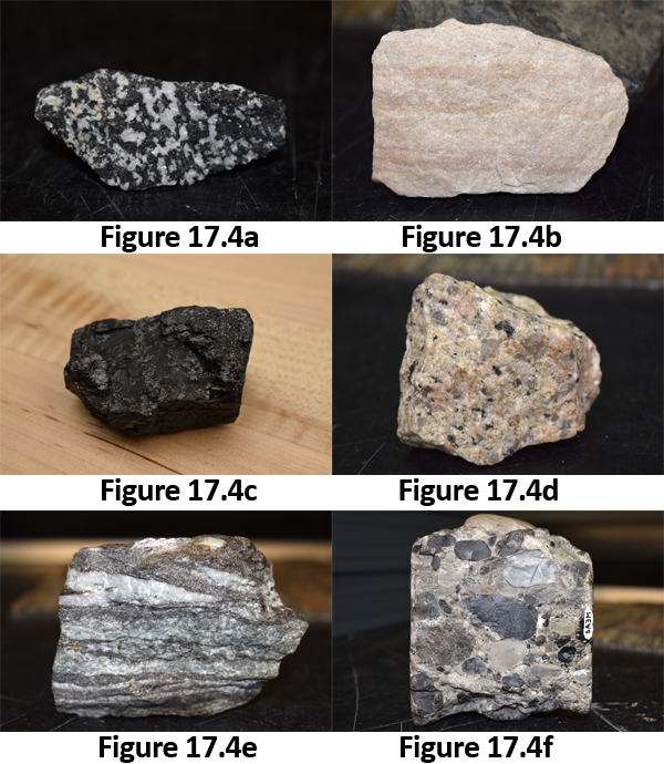
Figure 17.4. Igneous, sedimentary or metamorphic slide deck.
- Classify igneous rock samples 2A-2D in the slide deck below (Figure 17.5a–d) as intrusive (also known as plutonic) or extrusive (also known as volcanic), and provide a one-sentence explanation detailing your logic for each choice you made. If the slide deck does not display below, click here for Figure 17.5.
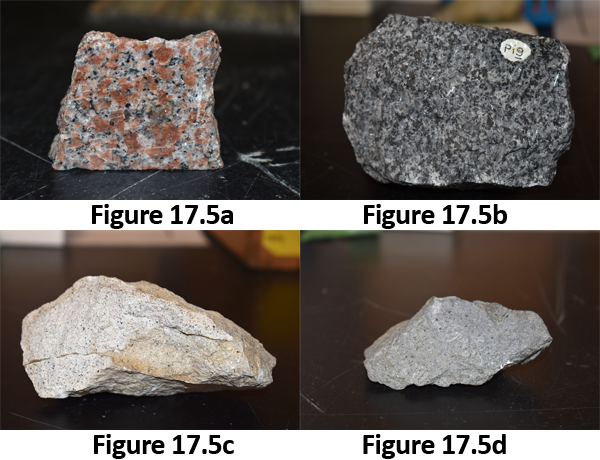
Figure 17.5. Igneous slide deck.
- Classify sedimentary rock samples 3A-3D in the slide deck below (Figure 17.6a–d) as clastic or carbonate or chemical, and provide a one-sentence explanation detailing your logic for each choice you made. If the slide deck does not display below, click here for Figure 17.6.
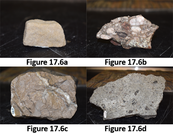
Figure 17.6. Sedimentary slide deck.
- Classify metamorphic rock samples 4A-4D in the slide deck below (Figure 17.7a–d) as foliated or non-foliated, and provide a one-sentence explanation detailing your logic for each choice you made. If the slide deck does not display below, click here for Figure 17.7.
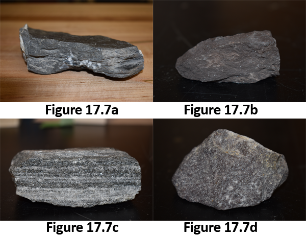
Figure 17.7. Metamorphic slide deck.
EX2: Plate Tectonic Boundaries
- Figure 17.1 (bottom) is a map showing the major plate boundaries found on Earth. The schematic cross-sections a) to d) show four models of relative plate motions. Download and use the map Detailed Tectonic Plate Boundaries [PDF] to determine which of these cross-sections best represents the plate motion at each of the numbered locations (1-9) found on Figure 17.1. Explain your answers. the numbered locations are at the following tectonic plate boundaries:
- African and Antarctic
- African and Arabian
- Indian-Australian and Eurasian
- Pacific and Eurasian
- Indian Australia and Pacific
- Pacific and North American
- Pacific and Antarctic
- Nazca and South American
- North American and African
- At which of these numbered boundaries would you expect to find old rocks that have been folded and deformed? Explain your answer.
- At which of these numbered boundaries would you expect to find young undeformed rocks? Explain your answer.
EX3: Geological Structure Basics
- Figure 17.8 shows a geological cross-section of the area near Banff, Alberta, Canada, that was created by the Geological Survey of Canada (GSC). Download a PDF version of Figure 17.8 Banff East-Half Cross Section [PDF] and the corresponding 1:50,000 Banff Geology map [PDF] (legend is on the map) so that you can view the area in more detail.
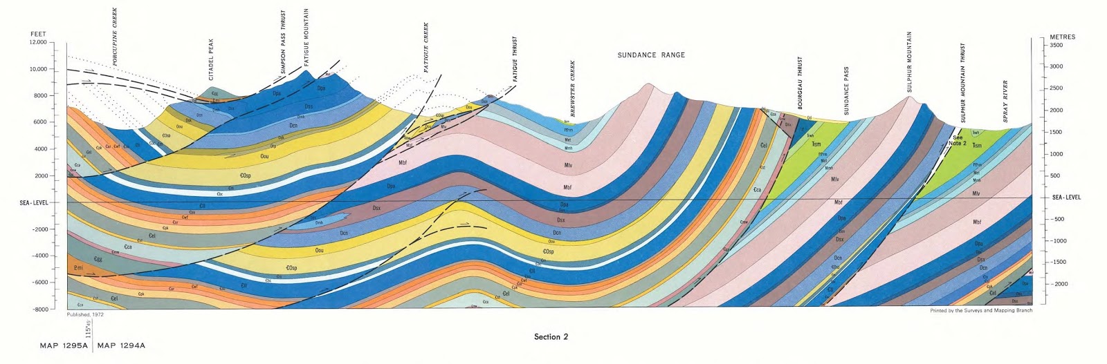
Figure 17.8. Geological Survey of Canada: Banff East-Half Cross Section.

- Match the structural features identified on the GSC Banff East-Half Cross Section and listed in Table 17.1 with the corresponding location name found on the 1:50,000 Banff Geology map.
- Which location name has the oldest rocks at the surface? Explain your answer.
- The Qd beds on the geological map are fundamentally different from all the other formations shown on the geologic cross section. In what way are they different?
EX4: Analysis of Rock Samples from British Columbia
- Examine the eight rock samples in the slide deck below (Figure 17.9a–h), then name the geologic belt on Figure 17.3 from which each sample was obtained.
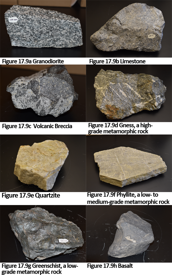
Figure 17.9. British Columbia rocks slide deck.
Provide a two-sentence rationale for your choice of geologic belt for each sample. In answering this question, use information on rock type supplied in BC’s Geologic History, along with information from the internet regarding the rock names. If the slide deck does not display below, click here for Figure 17.9.
Reflection Questions
- BC is quite unique in that is has mountain ranges dominated by sedimentary rocks (e.g., the Rocky Mountains), mountain ranges dominated by metamorphic rocks (e.g., the Monashee Mountains) and mountain ranges dominated by igneous rocks (e.g., the Coast Mountains). Assume you have never visited any of these mountain ranges and write a short 2-3 sentence explanation about which one you think would be most geologically interesting to you, and why.
- If you live in BC, which geologic belt do you live in, and what kinds of rocks are dominant in your area?
- Did students from similar areas post similar looking rocks? Why or why not?
- EX2 examined large global tectonic plate boundaries, but when you can look in more detail there is a lot more going on. Look closely at the western North American plate boundaries in the Detailed Tectonic Plate Boundaries [PDF] from EX2, and examine the boundaries that exist between the Pacific Plate, the Juan de Fuca Plate, and the North American Plate. Answer the following questions, and explain your thinking.
- What will eventually happen to the Juan de Fuca plate?
- Why are there volcanoes in the Cascade and Coast mountains?
- If you could see 20 million years into the future, where would you have to look for land west of the San Andreas Fault?
References
Cannings, R., & Cannings, S. (2004). British Columbia: A natural history. Greystone Books.
Media Attributions
- Figure 17.1: Image by D. McDonnell is licensed under a CC BY-NC-SA 4 .0 licence.
- Figure 17.2: Image by F. de Scally is licensed under a CC BY-NC-SA 4 .0 licence.
- Figure 17.3: Image by F. de Scally is licensed under a CC BY-NC-SA 4 .0 licence.
- Figure 17.8: Banff East Cross Section: Map 1294A/1295A by Geological Survey of Canada is licensed under the Open Government License.
Image Descriptions
Figure 17.3. Geological belts of British Columbia
map of the geological belts that can be found in the province of BC, and the bordering edges of the neighboring province (Alberta), territory (Yukon), and US States (Washington and Alaska). There are six geologic belts that each run as approximately northwest to southeast bands that roughly following the physiographic regions of the province.
The geologic belts of BC from west to east are:
- The insular belt; which covers the islands of BC (including Vancouver Island and Haida Gwaii), and the southern tip of the Alaskan mainland coast.
- The coast belt; which covers the mainland coast of BC from Vancouver, through Prince Rupert, and up through the BC-Yukon border to the edge of the Yukon-Alaska border.
- The intermontane belt; which covers part of the interior region of BC from the Okanagan (including Kelowna), Thompson (including Kamloops), and Nicola valleys in the south, to Prince George in the middle of BC, up to Whitehorse in the Yukon. The intermontane belt is widest in the middle of the province, from Prince George on the east side extending westward.
- The omineca belt; which contains the Kootenays (including Cranbrook) in the south where this belt is wide, through the middle of the province where it is quite narrow, up to Watson Lake in the Yukon where the belt becomes wide again.
- The foreland belt; which contains the Rocky Mountains. For the southern half of the Rocky Mountain range, the province of BC is on the west side, and the province of Alberta is on the east side. Further north, the mountain range runs entirely through BC.
- The interior plains; which contains the city of Calgary, Alberta in the south, and Dawson Creek, BC and Fort Nelson, BC in the north.
