Chapter 13. The Farthest West
13.3 Fur Trade and Empires
The Russians
The catalyst for European interest in the Pacific Northwest in the 18th century was Russian exploration. The Sv. Petr, under the command of Vitus Bering (1681-1741) arrived in the Aleutian Islands in 1741 as part of an exploratory expedition. The ship was wrecked, Bering died, and just enough of his crew survived to get home in a makeshift boat cobbled together from what was left of the Sv. Petr. They went back with sufficient sea otter pelts to win a small fortune. Russian entrepreneurs and shipowners were soon following in Bering’s path. Enslaving much of the indigenous Aleut (a.k.a. Unangan) population and terrorizing much of the rest, the Russian traders established a presence that eventually stretched south to California. These events occurred against a backdrop of growing Russian expansionism. Under Elizabeth of Russia and her successor, Catherine the Great, Russia’s imperial ambitions and aggressive posture grew. All this alarmed the Spanish (see below), who first heard of the move into Alaska in the imperial Russian court.
Bering and his successors may have had the blessings of the empresses, but they also faced great challenges, the first of which was supply lines. The huge cost of running their operation out of Okhotsk limited the Russians, which is one reason why they were largely uninterested in settlement until the 1780s and 1790s. The agricultural potential of Alaska, with its short growing season, was another impediment to self-sufficiency. The Russians faced further disadvantages in the marketplace. They were denied access to Guangzhou and had to carry their pelts across Siberia to Kyakhta, south of Lake Baikal, where they could cross the border into China. This added further costs.[1]
Some of the competitive elements of the Russian trade began to consolidate by the 1780s. In 1799 Czar Paul I decreed a Russian-American border at 55°N (near the southern limit of the Alaskan panhandle) and chartered a joint stock company to take monopolistic control of the fur trade: the Russian American Company (RAC). Almost immediately the company’s chief manager, Alexander Andreyevich Baranov (1746-1819), adopted a policy of contracting out to American ships in the region. In 1803 two Russians and some 40 Aleuts and Alutiiq otter hunters sailed to Baja California on board an American ship. Over the next decade, it is believed that tens of thousands of otters were captured along the California coast by Alaskan Aboriginals in the employ of — or, more typically, enslaved by — the RAC and working from American ships.
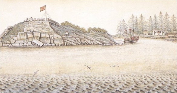
The first permanent Russian (and thus the first European) settlement in Alaska was established at Novo-Arkhangelsk (New Archangel, or Sitka) in 1804, which hardened Russian claims to the territory. As well, in 1812 the Russians were able to leapfrog their British and American competition and establish Fort Ross (a.k.a. Fortress Ross) in what is now northern California. All of these events coloured the Russians as something of a wildcard on the coast: the vulnerabilities to RAC’s supply line sustained independent and sometimes reckless traders; Russian relations with the Lingít (Tlingit) were terrible and poisoned Aboriginal-newcomer relations south of the panhandle; and the Russians never entirely lost sight of the possibility of a Californian colony — Fort Ross remained in Russian hands until 1841.
The Spanish
In 1774 a Spanish naval expedition under Juan Pérez (ca. 1725-1775) worked its way north from California in an effort to assess the threat posed by the Russian presence in Alaska. According to the Treaty of Tordesillas (1494), the whole of the West Coast was Spain’s to lose. The Portuguese honoured the treaty but the rest of Europe did not. Nor did the Aboriginal people of the northwest coast. And why should they? Spain had not ventured north of California, apart from the disputed 1592 voyage of Juan de Fuca in search of the legendary Strait of Anian.
Word of the Russian intrusion worried the Spanish sufficiently that in 1767 they established a naval station at San Blas and posts at San Diego and San Francisco two years later. Five years after that, the Spanish mustered Perez’s small expedition to chart and claim the North Pacific. Although the Spanish made their way as far north as Alaska and erected a cross there, they made no other landfall north of what is now Washington State. The Spanish were satisfied that there was no Russian presence between Mexico and 57°N.
A second expedition set out in 1779 under the Peruvian-born Juan Francisco Bodega y Quadra (1744-1794), sailing north again to Alaska. On this occasion the Spanish were looking for the outlet of a “northwest passage” that would lead to the Arctic Ocean or perhaps to the Saskatchewan or the Missouri Rivers. They sailed to 61°N and went ashore to ritually claim the territory, then returned home, assuming the job was done and that they could now relax or at least focus on the freshly announced war with Britain.
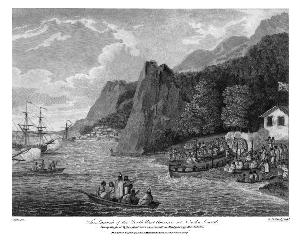
Having run up the flag on the northwest coast in 1774 and 1779, the Spanish were surprised to find they needed to monitor and perhaps defend their position, though not, as they might have expected, against Russia. Britain’s appearance in 1778 in the form of James Cook’s third expedition alerted the Spanish to the need to establish a fixed position on the north coast. In 1788 a pair of Spanish ships made another voyage to Alaska, this time finding the Russians and discovering that they had plans to establish a post on Nootka Sound in the territory of the Mowachaht. Returning to Mexico, the Spanish launched yet another expedition, intent on claiming Nootka Sound for their own. When they arrived they found two American ships and one British; the Spanish banished the latter and then seized the North West America, a vessel owned by the British independent trader, John Meares, and built on Nootka Sound by a crew of Chinese workers brought to Yuquot by Meares — the first Chinese arrivals in British Columbia. The Spanish put the Chinese to work building Fort San Miguel, thereby creating a physical statement of sovereignty. These aggressive efforts to assert Spanish sovereignty provoked what became known as the Nootka Crisis, which began in 1789 and lasted five years.
In terms of developing Aboriginal-European interaction, the Spanish had one advantage over their contemporaries: they alone of the European and North American visitors to the North Pacific had an interest in territory first and commercial ventures second. Once the British were disabused of the existence of a northwest passage their only concern was furs. The same was true, only more so, of the Russians and Americans. In contrast, Bodega y Quadra was looking at the long term, and therefore thinking about building lasting relationships with the Aboriginal people. This was what he hoped to do at Fort Miguel in 1791-93.
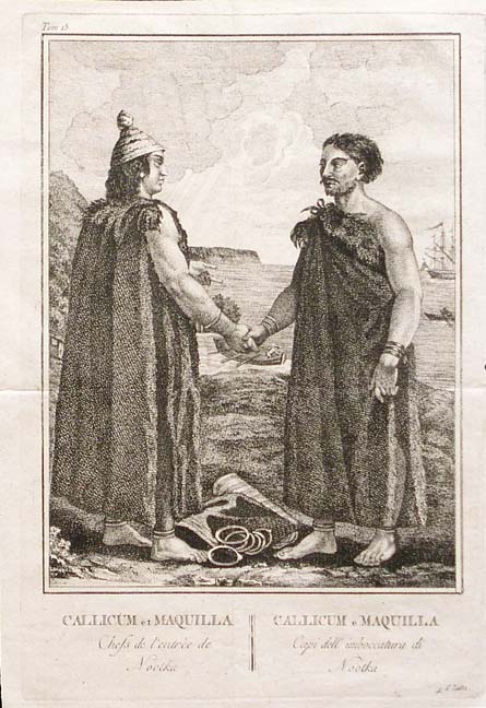
Bodega y Quadra was, by all accounts — and certainly by George Vancouver’s account — charming, curious, and smart. The leading figure among the Mowachat, Maquinna (ca. 1795), was particularly impressed with Bodega y Quadra’s ability to assimilate local customs and to show respect to the local leaders. And Bodega y Quadra’s reports on matters in Nootka Sound from 1790 to 1793 were insightful. These include his belief that Euro-American traders cynically stirred up trouble in order to improve the market for guns and ammunition; that syphilis was spreading unchecked from British and American ships to the indigenous population; that traders from abroad were never above plundering the Nuu-chah-nulth villages if they didn’t get what they wanted under terms that they wanted; and that the European responses to minor thefts or single murders by the Aboriginal population was typically a violent overreaction. Bodega y Quadra spent two years repairing relations after Callicum, one of the Nuu-chah-nulth leaders and a close relation of Maquinna, was shot dead by the Spanish (under circumstances that remain unclear).
Like the Russians, the Spanish operated under several important disadvantages. While they could trade into Chinese seaports (unlike the Russians) their objective was to obtain Asian mercury to support their gold and silver processing operations in Mexico. The sea otter trade was, for the British, Americans, and Russians, about selling cheaply acquired pelts and obtaining highly desirable Chinese products — tea, silk, porcelain — for sale at a further profit in Europe. For the Spanish, it was about enhancing gold production in Mexico. The “Mercury Fleet,” as it was known, from Europe, however, could deliver materials more cheaply than the Spanish could in the Pacific.
As well, the Spanish could hardly muster sufficient resources to blast British, American, and Russian competition off the coast. For that reason, and because they sensed that Mexico’s security might be compromised by Britain and/or America, they retreated.[2] As one historian has put it,
The Spanish regime lacked the motivation or the population to maintain its sovereign claims to the coastline and ocean north of California. Other than the northwest coast Natives sent to Mexico and perhaps a few mestizos born at Nootka Sound, the Spanish efforts left little impact upon the Native societies. […] Even before [the last of the Spanish and British ships left Yuquot in 1795], Maquinna’s people were hard at work erecting house posts for their summer village.[3]
The Nuu-chah-nulth would continue to trade with Europeans for decades, but they did not permit the outsiders to re-establish themselves anywhere on their coast. Fort San Miguel would be the last European toehold on Vancouver Island until the 1840s.
The British
European claims to a territory could have the most tenuous foundation. In 1577 Sir Francis Drake (1540-1596) sailed from Plymouth Harbour in England with orders from Queen Elizabeth I to terrorize and pillage the Spanish gold fleet in the Pacific Ocean. The mission evolved into England’s first circumnavigation of the globe but, more importantly for the history of the Pacific Northwest, it allowed Britain to lay claim to lands north of Mexico. Drake’s account puts him just north of San Francisco Bay in 1579, which he named Nova Albion (New Albion). Scholars continue to debate whether Drake ventured farther north, but this 16th century interlude was the basis on which Britain built its claim 200 years later. When he mapped a place on the northwest coast in the 1790s, Captain George Vancouver’s notations would include the phrase “from that part of New Albion.”[4]
In 1774, James Cook (1728-1779) led a British expedition into the Pacific Northwest. Cook’s ships rounded South Africa, Australia, and New Zealand, set out for Hawaii, then reached the Americas at Alta California. Sailing north, he narrowly missed both the Columbia River and Juan de Fuca Strait but found his way to Yuquot (Friendly Cove).
Cook spent a month there enjoying the hospitality of the Nuu-chah-nulth and becoming acquainted with their self-confident and sharp trading practices. The people of Yuquot and Tahsis weren’t satisfied with the cheaper goods that had been traded with the Hawaiians, and they controlled the terms of trade throughout. When they were done, Cook’s two vessels continued north and successfully rounded the North Pacific before heading back to Hawaii, where the captain was killed by the locals. The Resolution and the Discovery continued the voyage home, stopping in Guangzhou (Canton). There they discovered what the Russians already knew: the sea otter pelt market in China was extremely lucrative. British and American interest in the region was thereafter stimulated.[5]
Cook’s voyages provoked the Spanish to press their regional claims. The British pressed right back. The two countries nearly went to war over the question of whose claim was the stronger. Captain George Vancouver (1757-1798), was the British representative on the scene at Yuquot; Juan Francisco de la Bodega y Quadra represented the Spanish. Various accounts of this meeting have been written, at least one fictionalizing the encounter. What they have in common is Vancouver’s moodiness and obstinance compared with Bodega y Quadra’s smoothly seductive hospitality. Events in Europe were to overtake them: in 1792 the French Revolution was threatening to spread beyond the borders of France, and the Spanish decided to sacrifice their northwest coast claim in exchange for British goodwill. As a result, the British gained nominal control of everything between Alta California and Russian Alaska. The negotiators at Yuquot agreed to mark the event by naming the island after themselves. For many years it appeared on European and American maps as “Bodega y Quadra and Vancouver’s Island” (shortened later to Vancouver’s Island, and finally Vancouver Island).
In the Navy
James Cook and his contemporaries were some of the most remarkable cartographers of all time. Their maps are still reliable today, and Cook’s 1760s maps of Newfoundland were the gold standard into the 20th century. Their careers intersect with the stories of British North America, Australia, New Zealand, and Hawaii. Cook was at Louisbourg when it fell in 1755 and commanded a ship under Wolfe at the Battle of Quebec four years later. George Vancouver joined the Royal Navy at 13 and served with Cook from the age of 14. William Bligh was only seven when he was signed up with the navy and his career would see more than the usual amount of drama.
Cook once declared that his goal was to go “farther than any man has been before me, but as far as I think it is possible for a man to go.” Both Vancouver and Bligh had a chance to study under Cook and were with him on the last of his three voyages. They all kept their pencils pressed against map paper constantly. They were together on the Resolution in Hawaii when Cook made the fatal choice to go ashore one time too many. Vancouver’s career was just starting. He was barely 20 years old when he was given command of the Discovery, a four-year mission to explore the Pacific in greater detail, and a mandate to settle the practical terms of the Nootka Convention. Along with two Spanish captains, Dionisio Alcalá Galiano and Cayetano Valdés y Flores, he charted the Strait of Georgia (the Salish Sea) and passed within sight of the peninsula on which the city bearing his name was later built. Bligh, for his part, has an island bearing his name in Nootka Sound. He would take command of the Bounty in 1787, a ship irretrievably associated with mutiny.
Having sovereignty on paper, however, did nothing to enhance the British position. They continued to engage in trade, but that didn’t stop others parties from arriving on the coast. Like Quadra, Vancouver had little use for the travelling fur traders, particularly those who were selling guns. He regarded their tactics as deplorable and wrote to his superiors:
I am extremely concerned to be compelled to state here, that many of the traders from the civilised world have not only pursued a line of conduct, diametrically opposite to the true principles of justice in their commercial dealings, but have fomented discords, and stirred up contentions, between the different tribes, in order to increase the demand for these destructive engines… They have been likewise eager to instruct the natives in the use of European arms of all descriptions….[6]
In terms of imperial diplomacy, the British had come out ahead, but the Americans (see below) had the whip in hand when it came to trade. The British would have to change their strategy dramatically and the incentive to do so would come from Canada. By 1830 British traders were back in the game, supported by forts on the Columbia River and at Langley. It would be another 10 years before they could claim real regional domination over the other intruder traders. Authority over the Aboriginal population would take longer still.[7]
The Americans
Even as the American Revolution was raging it was clear to shipowners in East Coast ports that their access to British markets might be in danger. Britain took steps to prohibit American access to the West Indies market, a move that favoured the new British North American colonies and that left American ship captains looking farther afield. Necessity took them out of the North Atlantic and into the Mediterranean and North Africa, down the east coast of South America and round Cape Horn into the Pacific. It found them trading in the South China Sea and, almost inevitably, along the northwest coast.
There were two aspects to the American trade in the region. The first was its maritime face. The Americans put more ships into the region than any other nation. Although British ships dominated from 1785 to 1792, they were increasingly competing with American vessels (one-to-one in 1791 and 1792), as well as the occasional French or Portuguese ship. In the two decades that followed, the British presence slipped well behind that of the Americans. In 1801 more than 20 American vessels found their way to the Pacific Northwest; in the same year only three British ships and one Russian ship were in the area. Soon the British were down to one ship a year, although it was usually the same ship making repeat visits. The American fleet, by contrast, was made up of competing traders; often their name appears only once in the register. Continuity was an issue because one-timers tended to behave in ways that were not necessarily in the best interest of long-term trade relations. The sales of guns and alcohol were a particular problem. [8]
In short, as far as the maritime trade was concerned, the Americans had the edge. It was, however, an uncoordinated edge. The independent ships from Boston and other New England ports had no imperial mandate, nor were they acting on behalf of the new republic. Later American claims to the territory might invoke some of the earliest expeditions in the region, but the fur trade fleets were of little value in this regard.
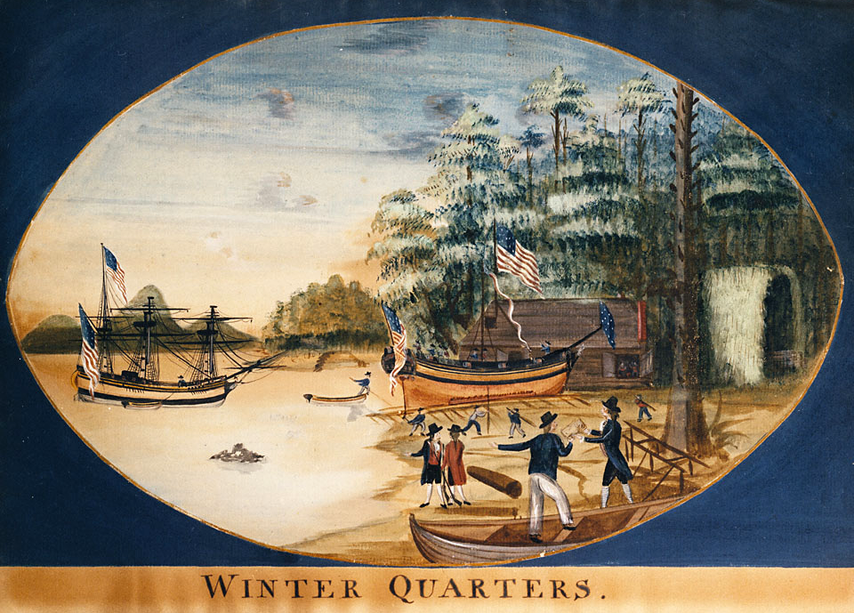
The land-based trade posed different advantages and liabilities. John Jacob Astor (1763-1848), a German immigrant to the United States who saw an opportunity in shipping Canadian furs through New York to Europe in the 1790s, amassed a substantial fortune in just a few years and was eager to involve himself more directly in the fur trade. He developed a multi-pronged strategy, one part of which was the Pacific Fur Company (PFC) and the prospect of a fort on the Columbia River, which he named for himself. Astor’s company seemed fated from the outset. The Tonquin disaster (see section 13.7 Identity Crisis) was the worst of it, but another of the PFC’s ships proved to be not seaworthy, a third was badly beat up by a storm, and a fourth was wrecked off the coast of Maui. One study estimates that the PFC lost 61 men in less than two years. The trade conducted from Fort Astor was negligible. Astor’s own employees were quickly turning against him, and war had broken out between the Americans and the British in North America.[9] A quick sale to the NWC in 1813 was the outcome.
One legacy of Astor’s expeditions was picked up by several American traders — that of provisioning other fur trading outposts, regardless of who owned them. The cost of establishing, maintaining, and provisioning a trading post in the region was all but prohibitive, but American suppliers offered a solution. Every post in the Pacific Northwest at some point took advantage of the opportunity to restock with American goods, even though doing so was essentially underwriting the costs of the competition. Severing this link between American suppliers and the Russian traders in particular was key to British success in the region, but that goal was only achieved in the 1830s. Thereafter the prohibitively high costs of trade in the region combined with sharply declining sea otter stocks to reduce American shipping to no more than a couple of ships a year.

The Imperial Coast
At some point, Spain, Russia, Britain, and the United States all claimed the Pacific Northwest. Spain dropped its interests with the Nootka Convention of 1793. Russia’s RAC reinforced its positions from Sitka north and west, marking a boundary at 54’40″N latitude in agreements with the United States and Britain in 1824 and 1825 respectively. American claims to the “Columbia Department” — which included New Caledonia (that is, most of modern British Columbia) along with the future states of Washington and Oregon — were to prove a problem in the 1840s, but otherwise American interest in the region was made up of individual merchant ships. British claims were based on prior discovery, exploration, and treaty rights. As is explored in the next section, the most important imperial agency was the Hudson’s Bay Company, which built on a foundation established by the NWC and engaged in active trade from the Lower Columbia River north to the Arctic Ocean. From 1816 through to the 1840s, few Americans and Europeans settled in the region and it remained — for these outsiders at least — a venue for trade and they had aspirations to do little more. The Canadians were a different matter.
Key Points
- European interest in the Pacific Northwest increased in the mid-18th century with the arrival of Russian sea otter traders in Alaska.
- Russian ambitions in the region included the establishment of permanent posts, subjugating much of the Native population and extending their reach to California.
- The Spanish were spurred into action in the northwest by the Russian presence and were far more interested in sovereignty than commerce.
- Nootka Sound (Mowachaht) was the intersection of commercial and diplomatic interests including the host Mowachaht/Nuu-chah-nulth people of Yuquot (Friendly Cove), the Spanish, the British, and nominally independent traders.
- The resolution of the Nootka Crisis gave Britain the pre-eminent European claim to Vancouver Island and the mainland coast from California to Alaska, but it would be nearly 40 years before they established a post in what is now British Columbia.
- American traders were the dominant force in the maritime fur trade into the 1830s and their supply lines sustained the Russian presence, making it difficult for the British to turn a profit.
- The American Pacific Fur Company was the first to establish a fixed presence on the mainland, at Fort Astoria, although this soon fell to the Canadians.
- The establishment of British forts from Fort Vancouver north to Fort Stikine was a response to the mobile American fur trade.
Attributions
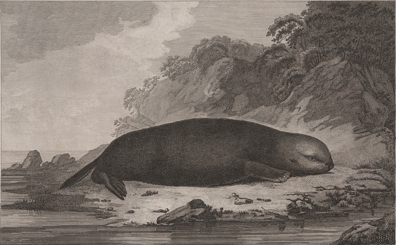
Figure 13.7
Sea Otter by Trycatch is in the public domain.
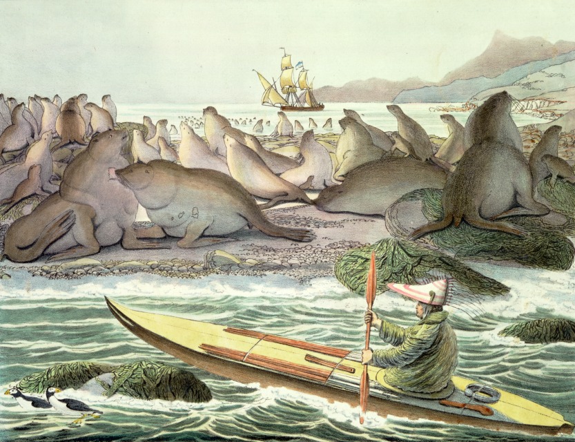
Figure 13.8
Choris, Saint Paul by Triggerhappy is in the public domain.
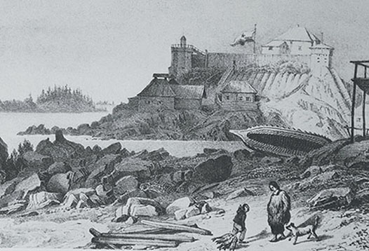
Figure 13.9
1827 illustration of Castle Hill by File Upload Bot (Magnus Manske) is in the public domain.
Figure 13.10
Callicum und Maquinna by Hans-Jürgen Hübner is in the public domain.
Figure 13.11
Spanish fort San Miguel at Nootka in 1793 by Onofre Bouvila is in the public domain.
Figure 13.12
The launch of the North West America at Nootka Sound by PawełMM is in the public domain.
Figure 13.13
Columbia Winter Quarters by Pfly is in the public domain.
Figure 13.14
Stamp of Russia 2012 No 1633 Fort Ross by Dmitry Ivanov is not an object of copyright.
- James R. Gibson, "Bostonians and Muscovites on the Northwest Coast, 1788-1841," in British Columbia: Historical Readings, eds. W. Peter Ward and Robert A. J. McDonald (Vancouver: Douglas & McIntyre, 1981), 70. ↵
- Christon I. Archer, “The Transient Presence: A Re-appraisal of Spanish Attitudes Toward the Northwest Coast in the Eighteenth Century,” in British Columbia: Historical Readings, eds. W. Peter Ward and Robert A. J. McDonald (Vancouver: Douglas & McIntyre, 1981), 37-65. ↵
- Christon I. Archer, “Seduction before Sovereignty: Spanish Efforts to Manipulate the Natives in Their Claims to the Northwest Coast,” in From Maps to Metaphors: The Pacific World of George Vancouver, eds. Robin Fisher and Hugh Johnston (Vancouver: UBC Press, 1993), 159. ↵
- Cole Harris, The Resettlement of British Columbia: Essays on Colonialism and Geographical Change (Vancouver: UBC Press, 1997), 31. ↵
- Robin Fisher, Contact and Conflict: Indian-European Relations, 1774-1890, 2nd ed. (Vancouver: UBC Press, 1992), 1-23. ↵
- George Vancouver, A Voyage of Discovery to the North Pacific Ocean, and Round the World: In which the Coast of North-west America Has Been Carefully Examined and Accurately Surveyed : Undertaken by His Majesty's Command, Principally with a View to Ascertain the Existence of Any Navigable Communication Between the North Pacific and North Atlantic Oceans, and Performed in the Years 1790, 1791, 1792, 1793, 1794, and 1795, in the Discovery Sloop of War, and Armed Tender Chatham, Under the Command of Captain George Vancouver : in Three Volumes, Vol.2 (London: G.G. & J. Robinson, 1798), 364. ↵
- James R. Gibson, Otter Skins, Boston Ships, and China Goods: The Maritime Fur trade of the Northwest Coast, 1785-1841 (Montreal & Kingston: McGill-Queen’s University Press, 1992), table 1, pp.299-310. ↵
- Ibid. ↵
- Richard Mackie, Trading Beyond the Mountains: The British Fur Trade on the Pacific, 1793-1843 (Vancouver, UBC Press, 1997), 15-16. ↵

_by_Postels.jpg)