Chapter 13. The Farthest West
13.6 Boundary Disputes and Manifest Destiny
Beginning in the early 1840s, “Oregon Fever” gripped the United States. Oregon was touted as a land of pleasant climates and fertile soil. Several thousand American settlers began a westward migration over the Oregon Trail. By the mid-1840s, some 5,000 Americans had populated the southern half of the Columbia Department, thus strengthening the U.S. claim to Oregon, and in 1843 the Americans declared a provisional government. The HBC’s James Douglas wrote to his superiors that “An American population will never willingly submit to British domination.”[1] Britain’s tenuous hold on the whole region was in danger of slipping away. Oregon Fever, moreover, fuelled the idea of Manifest Destiny in America, popularizing the the notion that it was God’s will that the republic should control the whole of the continent.
Fifty-Four Forty
American territorial expansion became one of the paramount issues of the U.S. election of 1844. Democrat James K. Polk, a protege of the expansionist Andrew Jackson (president, 1829-37), won office in an election that revolved largely around the issues of the possible annexation of Texas and acquiring some or all of the HBC-administered Columbia Department, which the Americans referred to as the Oregon Territory. Polk won the election by a narrow majority, but the Democrats took both houses of Congress, causing many to read the result as a mandate for expansionism.
Many Americans, Polk among them, set their sights on taking the Mexican provinces of New Mexico and California in addition to the Oregon Territory, which at that stage constituted most of the territory between California and the Alaska panhandle — that is, almost all of what is now British Columbia. Polk’s priority, however, was the Mexican territories and so he needed to quickly settle with the British on the issue of the Columbia Department in order to have the military strength for a war against Mexico. The process was further complicated by signs that Britain was considering an alliance with the Mexicans in Texas, so getting the British out of the picture was a priority.
On taking office, Polk initiated talks with Britain. The president quickly found himself a prisoner of his own expansionist rhetoric: public opinion over the Oregon Territory had grown increasingly heated with expansionists demanding nothing less than the whole package and threatening war in the far northwest in order to achieve their ends. The slogan Fifty-Four Forty or Fight! was coined at this time, referring to the northernmost latitude of the territory that America might claim, some 30 kilometres north of present-day Prince Rupert.
49th Parallel
British enthusiasm for war in the Pacific Northwest was understandably tepid. In 1845 and 1846 the fur trade was becoming less profitable and alternative economic engines were slow to emerge. Few politicians in Britain were prepared to go to bat for the monopolistic HBC, which was widely regarded as a bloated artifact of a pre-free trade era. There was little sign — not along the Fraser River or even in California — of the gold rushes that would transform the West Coast. Nor was there any indication of the potential coal mines of Vancouver Island. In this light it is not surprising that the British were prepared to concede as much as they did. Conveniently for the British, President Polk was more than willing to accept a boundary line along the 49th parallel.
In terms of the British interest, as represented in the field by the HBC, the circumstances had changed since the Treaty of 1818, paving the way for joint occupation of the Columbia District. The fur trade in the whole region was in decline and the corridor that ran from York Factory to Fort Vancouver at the mouth of the Columbia had lost much of its significance. In its place, as historian Richard Mackie notes, the HBC had built a network of deep-sea trade that linked ports in Hawaii, Alaska, Guangzhou, and California to Fort Victoria. The mouth of the Columbia was treacherous with shifting sands and channels; Fort Victoria was better suited for this new kind of commerce under Britain’s growing philosophy of free trade.[2] Holding the line at the 49th parallel and keeping Vancouver Island was sufficient to the needs of the British and, if it could be done through diplomacy rather than at gunpoint, a peaceful outcome was preferable to war.
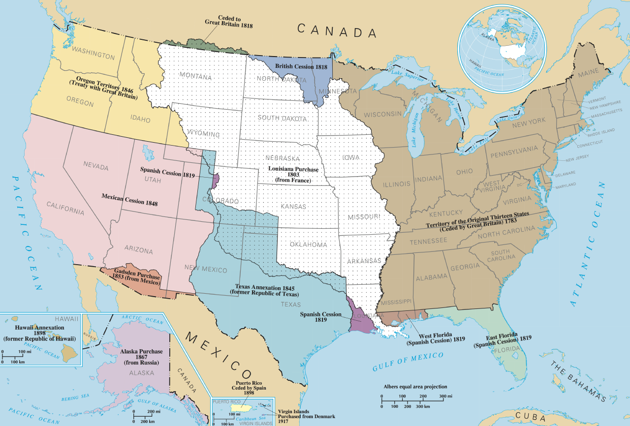
Two important results of the Oregon Treaty of 1846 were not committed to any legal document. First, the principles by which Europeans had sorted out who owned what in the New World shifted. The British claim was based on commerce and, indeed, every expression of British policy in the region from the 1780s to the 1870s hinged on commerce. When the British laid claim to the region based on occupation, they were using the word to mean “business”; in other words, they were occupied with commerce in the region. For the Americans occupation meant settlement, and sending in thousands of squatters to take up land was a precursor to annexation. With that American interpretation in mind, the HBC moved in the late 1840s toward a policy of building settlements on Vancouver Island to forestall any American forays into the region.[3] It was, as well, a lesson that James Douglas would remember at the right moment in 1858 and one that would focus Canadian minds when it came to holding Rupert’s Land against American intrusion from 1869 on. The map in Figure 13.19 shows those areas where American expansion in the West was a source of concern for British and Canadian interests.
The other result of the Oregon Treaty was a severely changed political landscape for Aboriginal nations. The 49th parallel cut through Native communities like a knife, effectively trapping populations on either side within rapidly emergent imperialist administrative structures. The change was not immediately apparent: the swoop of a pen 4,000 miles away makes little noise. By the late 19th century, however, both the American and the British-Canadian governments in the region were aggressively managing border peoples, some of whom found their societies divided.
Key Points
- American imperial aspirations in the second quarter of the 19th century included annexation of the whole Pacific Northwest.
- The Oregon Treaty of 1846 resolved the potential conflict between Britain and the United States by continuing the border with British North America all the way to the West Coast and throwing in all of Vancouver Island on the British side.
- The HBC and the Colonial Office had to develop new strategies to continue exploiting and claiming the territory between the American and Russian territories.
Attributions
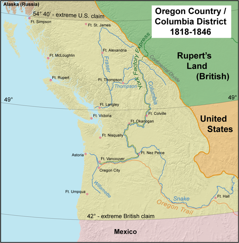
Figure 13.18
Oregon Country by Kmusser is used under a CC-BY-SA 2.5 license.
Figure 13.19
United States Expansion by Peteforsyth is in the public domain.
Long Descriptions
Figure 13.19 long description: American expansion from the original 13 states ceded by Great Britain in 1783 to the west coast. 1803 marked the completion of the Louisiana Purchase from France. In 1819, the Spanish ceded three southern states. Texas was annexed in 1845. In 1846 and 1848, America gained all of the western block of what is now the United States. In 1867, America bought Alaska from Russia. [Return to FIgure 13.19]
- James Douglas to George Simpson (private correspondence), 23 October 1843, quoted in Daniel W. Clayton, Islands of Truth: The Imperial Fashioning of Vancouver Island (Vancouver: UBC Press, 2000), 219. ↵
- Richard Mackie, Trading Beyond the Mountains: The British Fur Trade on the Pacific, 1793-1843 (Vancouver: UBC Press, 1997), 256-61. ↵
- Clayton, Islands of Truth, 222-3. ↵
