Chapter 17 Shorelines
Chapter 17 Summary
The topics covered in this chapter can be summarized as follows:
| 17.1 | Waves | Waves form when wind blows over water. The size of the waves depends on the wind speed, the area over which it is blowing, and time. The important parameters of a wave are its amplitude, wavelength, and speed. The water beneath a wave is disturbed to a depth of one-half the wavelength, and a wave is slowed when it approaches shallow water. A longshore current develops where waves approach the shore at an angle, and swash and backwash on a beach move sediment along the shore. The combined effect of these two processes is sediment transport by longshore drift. |
|---|---|---|
| 17.2 | Landforms of Coastal Erosion | Coasts that have experienced uplift within the past several million years tend to have irregular shapes and are dominated by erosional processes. Wave paths are bent where the coast is irregular and wave energy is focused on headlands. Rocky headlands are eroded into sea caves, arches, stacks, and sea cliffs, and the areas around these features are eroded into wave-cut platforms. Over the long term (millions of years), irregular coasts are straightened. |
| 17.3 | Landforms of Coastal Deposition | Coasts that have not been uplifted for tens of millions of years tend to be relatively straight, and are dominated by depositional features, although deposition is also important on irregular coasts. Waves and longshore drift are important in controlling the formation of beaches, as well as spits, tombolos, baymouth bars, and barrier islands. Beaches can be divided into zones, such as foreshore and backshore, and beach shapes typically change from season to season. Carbonate reefs and carbonate sediments form in tropical regions where there is little input of clastic sediments. |
| 17.4 | Sea-Level Change | The relative levels of the land and sea have significant implications for coastal processes and landforms, and they have been constantly changing over geological time. Eustatic sea-level changes are global in effect, and are typically related to glacial ice formation or melting. Isostatic sea-level changes are local effects caused by uplift or subsidence of continental crust, typically because of the gain or loss of glacial ice. Tectonic sea-level changes are related to plate interactions. Net sea-level rise leads to development of estuaries and fiords, while net sea-level drop creates uplifted marine terraces and beaches. |
| 17.5 | Human Interference with Shorelines | Humans have a strong urge to alter coasts for their own convenience by building seawalls, breakwaters, groynes, and other barriers. Although these types of features may have economic and other benefits, they can have both geological and ecological implications that must be considered. |
Questions for Review
1. What factors control the size of waves?
2. Referring to Table 17.1, approximately what size of waves (amplitude and wavelength) would you expect with a 65 km/h wind blowing for 40 hours over 1,000 km of sea?
3. If the average wavelength of a series of waves is 100 m, at what depth of water will the waves start to feel the bottom, and how will that change their behaviour?
4. What is the difference between a longshore current and longshore drift?
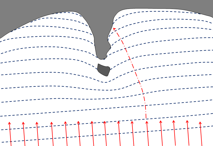
5. On this diagram, the waves (dashed blue lines) are approaching an irregular coast. The red arrows represent the energy of those waves, and one has been extended to show where that energy would hit the shore. Extend the other “energy lines” in a similar way, and comment on how this relates to erosion of this coastline.
6. Explain the origins of a wave-cut platform.
7. How do we define the limits of the beach face, and what are some other terms used to describe this zone?
8. A spit is really just a beach that is only attached to the shore at one end. What conditions are necessary for the formation of a spit?
9. Barrier islands are common along the Atlantic coast of the U.S. as far north as Massachusetts. Why are there almost none in the northeastern U.S. or along the coasts of New Brunswick, Nova Scotia, and Newfoundland?
10. This diagram represents an island on the central coast of B.C. that has experienced 140 m of isostatic rebound since deglaciation, and has also been affected by the global eustatic sea-level rise over the same period. The dashed line marks sea level during glaciation. How much higher or lower should that line be now?
11. If a dam were to be built on the Fraser River near Hope, what would be the long-term implications for beaches in the Vancouver area? Explain why.


