Chapter 18 Geology of the Oceans
18.1 The Topography of the Sea Floor
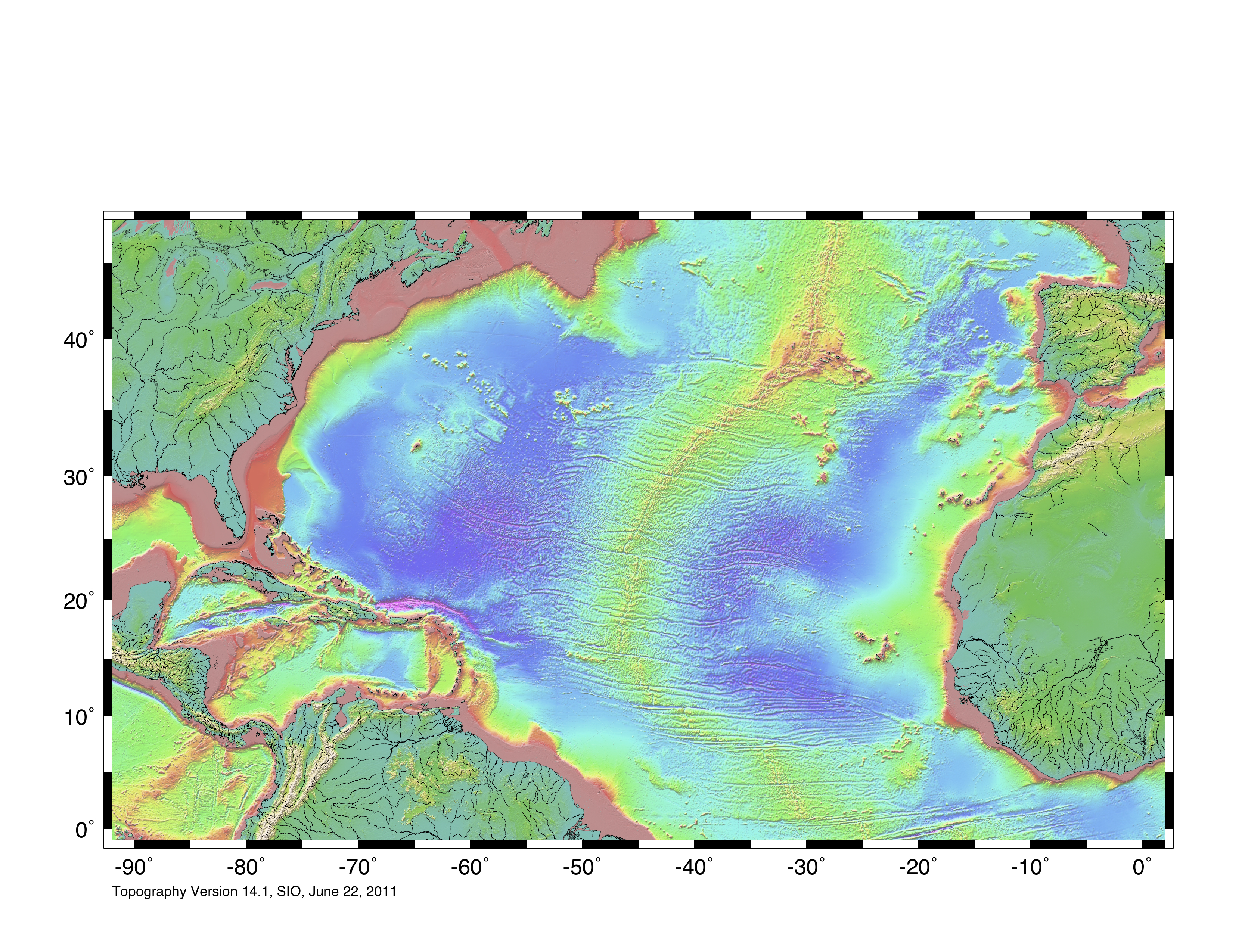
We examined the topography of the sea floor from the perspective of plate tectonics in Chapter 10, but here we are going to take another look at bathymetry from an oceanographic perspective. The topography of the northern Atlantic Ocean is shown in Figure 18.1.1. The important features are the extensive continental shelves less than 250 metres deep (pink); the vast deep ocean plains between 4,000 and 6,000 metres deep (light and dark blue); the mid-Atlantic ridge, in many areas shallower than 3,000 metres; and the deep ocean trench north of Puerto Rico (8,600 metres).

A topographic profile of the Pacific Ocean floor between Japan and British Columbia is shown in Figure 18.1.2. Be very careful when interpreting this diagram (and others like it), because in order to show the various features clearly the vertical axis is exaggerated, in this case by about 200 times. The floor of the Pacific, like those of the other oceans, is actually very flat, even in areas with seamounts or deep trenches. The vast sediment-covered abyssal plains of the oceans are much flatter than any similar-sized areas on the continents.
The main features of the Pacific Ocean floor are the continental slopes, which drop from about 200 metres to several thousand metres over a distance of a few hundred kilometres, the abyssal plains—exceedingly flat and from 4,000 metres to 6,000 metres deep, volcanic seamounts and islands, and trenches at subduction zones that are up to 11,000 metres deep.
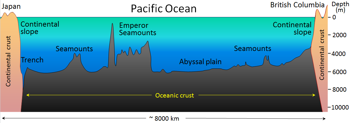
The ocean floor is almost entirely underlain by mafic oceanic crust (mostly basalt and gabbro, as described in more detail below), while the continental slopes are underlain by felsic continental crust (mostly granitic and sedimentary rocks). And, as you’ll remember from Chapter 10, the heavier oceanic crust floats lower on the mantle than continental crust does, and that’s why oceans are oceans.
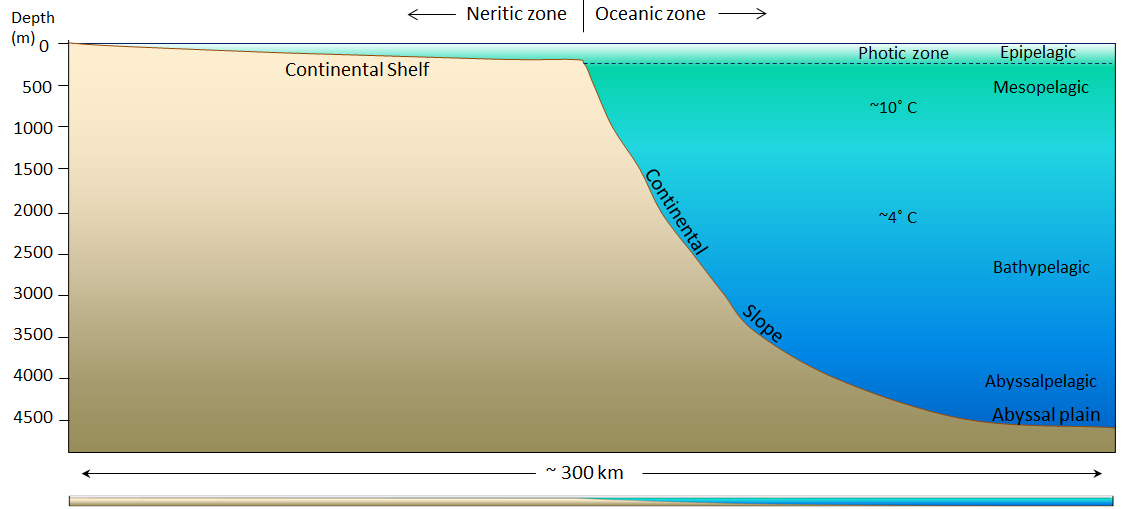
The continental shelf and slope offshore from Nova Scotia is shown in Figure 18.1.3. In this passive-margin area (no subduction zone), the shelf is over 150 kilometres wide. On the Pacific coast of Canada, the shelf is less than half as wide. Continental shelves are typically less than 200 metres in depth; 200 metres is also the limit of the photic zone, the maximum depth to which sufficient light penetrates to allow photosynthesis to take place. As a result of that photosynthesis, the photic zone is oxygenated, and therefore suitable for animal life. Approximately 90% of marine life is restricted to the photic zone. The photic zone is also known as the epipelagic zone. The mesopelagic zone extends from 200 metres to 1,000 metres, the bathypelagic zone from 1,000 metres to 4,000 metres, and abyssalpelagic zone is deeper than 4,000 metres. (Pelagic refers to the open ocean, and thus excludes areas that are near to the shores or the ocean floor.)
Although the temperature of the ocean surface varies widely—from a few degrees either side of freezing in polar regions to over 25°C in the tropics—in most parts of the ocean, the water temperature is around 10°C at 1,000 metres depth and about 4°C from 2,000 metres depth all the way to the bottom.
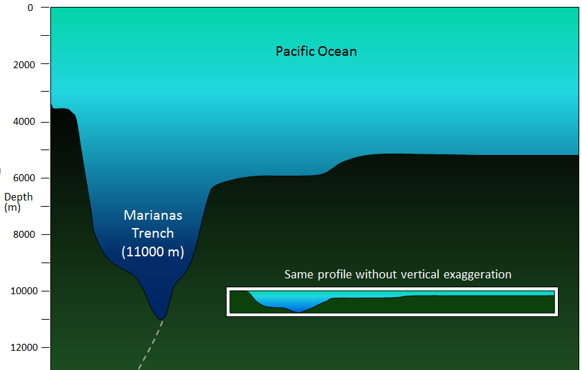
The deepest parts of the ocean are within the subduction trenches, and the deepest of these is the Marianas Trench in the southwestern Pacific (near Guam) at 11,000 metres (Figure 18.1.4). There are other trenches in the southwestern Pacific that are over 10,000 metres deep; the Japan Trench is over 9,000 metres deep; and the Puerto Rico and Chile-Peru Trenches are over 8,000 metres deep. Trenches that are relatively shallow tend to be that way because they have significant sediment infill. There is no recognizable trench along the subduction zone of the Juan de Fuca Plate because it has been filled with sediments from the Fraser and Columbia Rivers (or their ancient equivalents).
Exercise 18.1 Visualizing sea floor topography
This map shows a part of the sea floor.
- Identify the following features.
- a continental shelf
- a continental slope
- a spreading ridge
- a subduction zone with a deep trench
- an abyssal plain
- some isolated seamounts
- Where is this? (North is up.)
Image Descriptions
Figure 18.1.1 image description: Along the coast, the Atlantic Ocean is less than 2,000 metres deep. The depth increases farther from shore. In the middle, the Atlantic Ocean can be anywhere from 4000 to over 6,000 metres deep. A ridge stretches across the centre of the Atlantic Ocean in a northeast direction. The ridge causes the ocean depth to decreases to less than 2,000 metres. [Return to Figure 18.1.1]
Figure 18.1.3 image description: The continental shelf stretches out about 150 kilometres from the shore and the depth does not increase more than 300 metres. Once the continental slope begins, the depth continues to drop until it reaches 4500 metres at 300 kilometres from the shore. [Return to Figure 18.1.3]
Media Attributions
- Figure 18.1.1: “Seafloor Topography: Topo 8” by NASA/CNES. Public domain.
- Figures 18.1.2, 18.1.3, 18.1.4: © Steven Earle. CC BY.
- Figure 18.1.5: “Seafloor Topography: Topo 16” by NASA/CNES. Public domain.
the shallow (typically less than 200 metres) and flat sub-marine extension of a continent
the extremely flat surface of the deep ocean floor in areas unaffected by plate tectonic processes and volcanism
the flat surface of the deep ocean, typically beyond the limits of the continental slopes
the upper 200 metres of the ocean or a lake, where, depending on the turbidity of the water, light can penetrate
the upper layer of water (0 to 200 metres) in areas of the open ocean
the upper middle zone of the open ocean extending from a 200 to 1000 metre depth
the moderately deep parts of the ocean, between 1000 and 4000 metres
the deeper parts of the ocean, between 4000 and 6000 metres
the part of a lake or the ocean that is not close to shore
