Chapter 21 Geological History of Western Canada
21.4 Western Canada during the Mesozoic
The Mesozoic extends over 187 million years from the beginning of the Triassic (252 Ma) to the end of the Cretaceous (65.5 Ma). It was a particularly important period for the geology of western Canada. During this time, several continental collisions occurred along the west coast, resulting in the formation of the Rocky Mountains and the accretion (addition) of much of the land mass of British Columbia, and continuing deposition within the WCSB.
Terrane Accretion in British Columbia and Yukon
Continued subduction along the western edge of North America carried a number of continental terranes toward the coast, with the first collisions taking place in the early part of the Triassic, as the Quesnel, Cache Creek, and Stikine Terranes combined to form the Intermontane Superterrane, so named because it forms the interior plateau of British Columbia, between the Rockies to the east and the Coast Range to the west (Figure 21.4.1).


Approximately 100 million years later, another pair of terranes—Alexander and Wrangellia—collided to form most of Vancouver Island and Haida Gwaii, plus a significant part of Alaska. During the Cenozoic, additional terranes (the Outboard terranes) were added to the western edge of North America. An overview of the accreted terranes of B.C., Yukon, and Alaska is given in Figure 21.4.2.
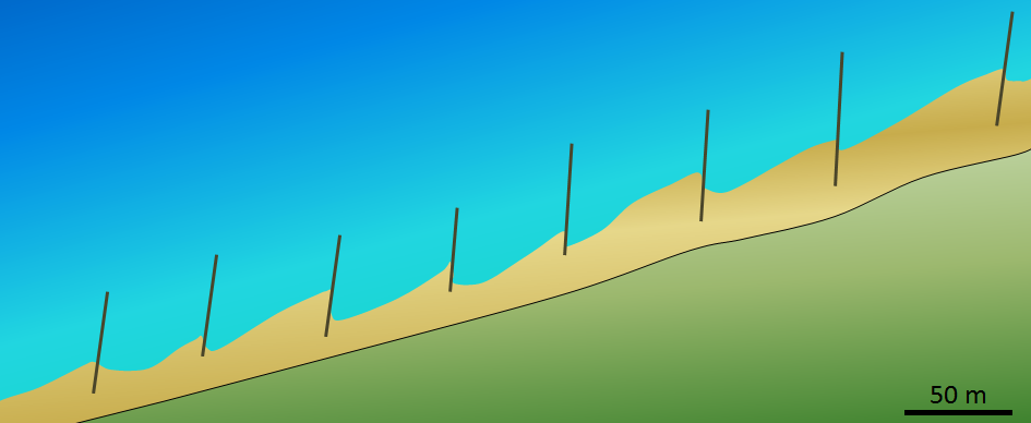
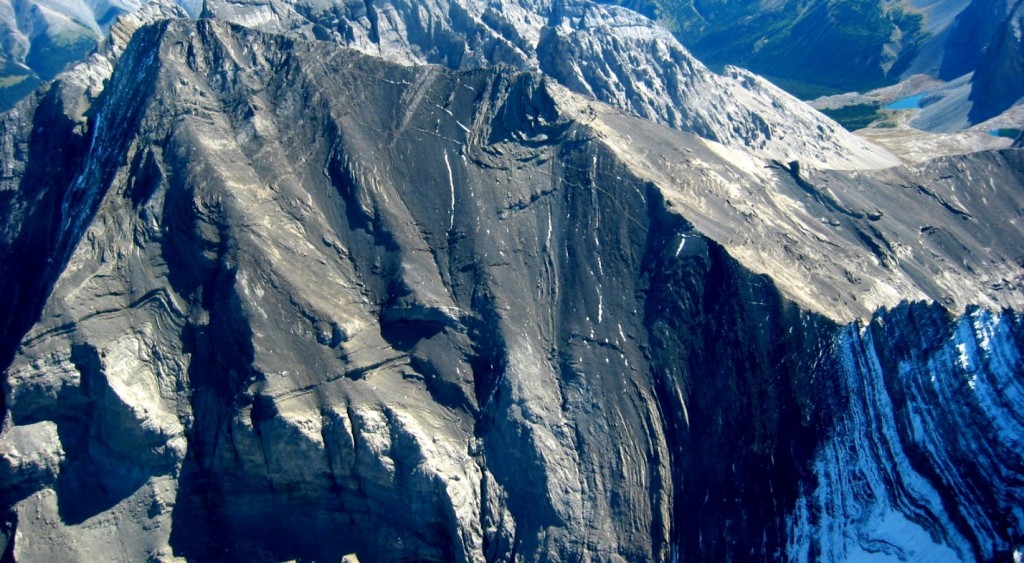
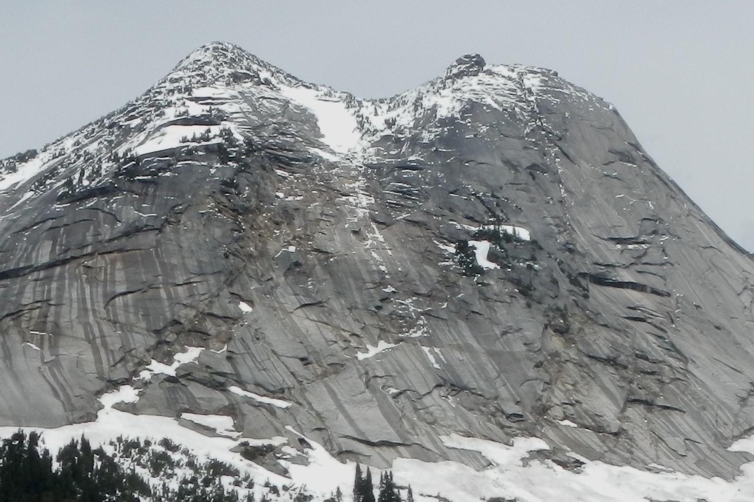
During the Jurassic, the Intermontane Superterrane acted like a giant bulldozer, pushing, folding, and thrusting the existing Proterozoic and Paleozoic west coast sediments eastward and upward to form the Rocky Mountains (Figure 21.4.3). The same process continued into the Cretaceous as the Insular Superterrane collided with North America and pushed the Intermontane Superterrane farther east. Folding in Rocky Mountain rocks, like that shown in Figures 21.4.4 and 21.4.5, is one of the results of this process.
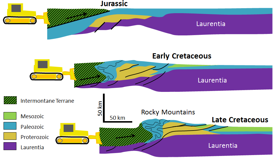
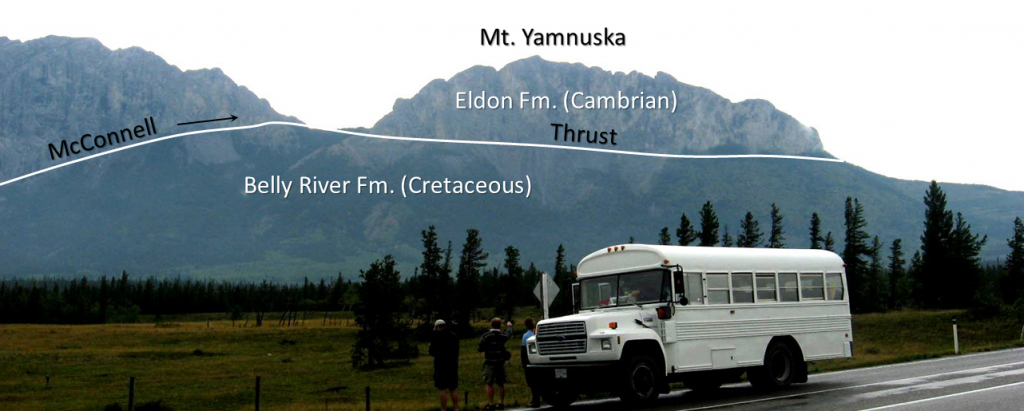
Thrusting is another important process in the formation of fold-belt mountains, as described in Chapter 12. During plate convergence, entire sheets of sedimentary rock are slowly pushed over top of other sheets, resulting in situations where older rocks lie on top of younger ones. One of the best known examples of this is at Mt. Yamnuska, near Exshaw, Alberta (Figure 21.4.6), where the older Cambrian rocks were pushed east by a total of 40 km, over top of younger rocks.
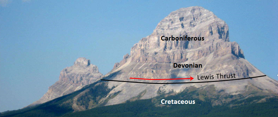
In the area near the U.S. border, within B.C., Alberta, and Montana, a sheet of Paleozoic rocks has been thrust about 80 km east over top of Cretaceous rocks along the Lewis Fault (Figure 21.4.7).
Not only did the subduction of oceanic crust beneath North America during the Mesozoic deliver geologically exotic terranes to the western edge of the continent, it also resulted in massive amounts of volcanism along the boundary (Figure 21.4.1). The upper-crustal magma chambers that fed those now-eroded volcanoes slowly cooled into granitic and dioritic stocks, and those stocks gradually coalesced into batholiths that extend from the southwest corner of B.C. all the way into Yukon and Alaska (Figures 21.4.8 and 21.4.9). Most of the granitic rocks of this region fall into two main age ranges: many are middle-Jurassic to early Cretaceous in age (~ 170 Ma to 140 Ma), while others are late Cretaceous to Paleogene (~50 Ma to 90 Ma). Many of the older bodies intruded into the terranes they are on before they arrived on the North America coast. This applies to those on Vancouver Island and Haida Gwaii. Some of the older ones formed in situ when the subduction zone was farther east (see Figure 21.4.1). Most of the younger bodies formed in situ when the subduction zone was close to where it is now (west of Vancouver Island) or slightly to the east.
Although these intrusive igneous rocks cooled at depth in the upper crust, they now form some of the highest peaks in Canada, many of them hundreds of metres higher than those of the Rocky Mountains (including Mt. Waddington, the highest peak entirely within British Columbia at 4,091 m). It is estimated that over the past 100 million years some of these igneous bodies have been uplifted in the order of 8,000 m. Much of that uplift is a result of the relative low density of the granitic rocks compared with the surrounding rocks.
The Western Canada Sedimentary Basin during the Mesozoic
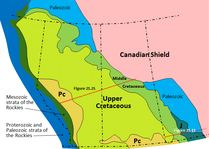
The construction of the Rocky Mountains during the Jurassic and Cretaceous—and their ensuing erosion—created a significant new source of sediments for the WCSB. Based on the ages, distributions, and thicknesses of the sedimentary layers (Figure 21.4.11), it is evident that the greatest volumes of sediment were produced in the Upper Cretaceous (100 Ma to 65 Ma) and into the Paleocene (65 Ma to 55 Ma). The sediments accumulated in a basin that is thought to have been at least partly formed by the presence of a subducting slab of oceanic lithosphere underneath this part of North America. However, the ongoing uplift of the Rockies through this time period also led to isostatic depression of the crust. The western edge of the basin, which has about 4,500 m of Mesozoic rock alone, is a foreland basin. (See Chapter 6 for more on the origins of basins.)
From time to time during the Mesozoic, the WCSB was filled to varying degrees with marine water. The Jurassic rocks at the base of the sequence are marine in origin, although the Jurassic sequence in Manitoba also includes evaporite layers. Most of the Middle Cretaceous rocks across the basin are marine, but the majority of the Upper Cretaceous rocks are of terrestrial origin, deposited within the flood plains and deltas of rivers. Some of these terrestrial sediments include coal layers; as described in Chapter 20, there are significant coal deposits in central Alberta.
The Paleozoic sediments within the WCSB were buried deeply beneath the Mesozoic sediments and were heated enough to form both oil and gas. There are large petroleum resources in reservoir rocks of various ages extending from northeastern B.C. to southwestern Manitoba.

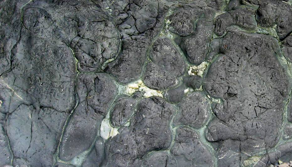
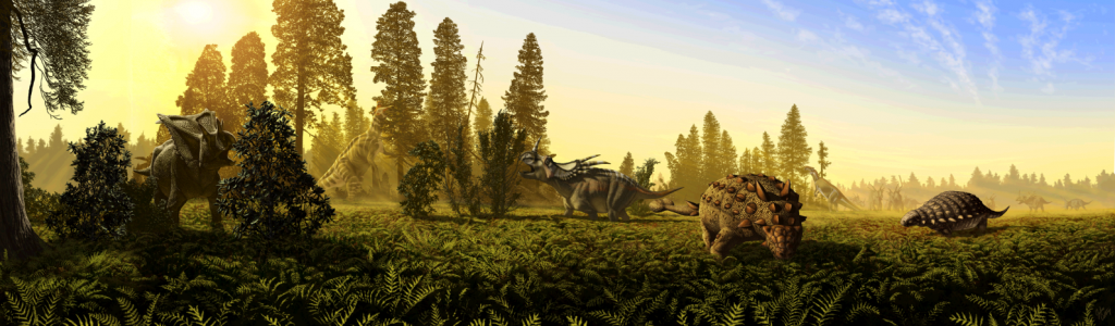
Several of the terrestrial Cretaceous formations in the WCSB are host to important dinosaur fossils. Some are within B.C. and Saskatchewan, but the most famous are in Alberta, including the Dinosaur Park Formation (Figure 6.0.1), the Scollard Formation, and the Horseshoe Canyon Formation (Figure 21.4.12). The Dinosaur Park Formation has one of the greatest concentrations of dinosaur fossils of any rock on Earth, with at least 50 genera of dinosaurs represented, ranging from tiny Hesperonychus to giant Albertosaurus. The Hilda Bone Bed, situated about 80 km to the east of Dinosaur Park, is estimated to have the remains of approximately 1500 ceratopsians, all of which are interpreted to have died in a flood related to a tropical storm. A few of the larger herbivorous dinosaurs found at Dinosaur Park are illustrated in Figure 21.4.13.
Exercise 21.4 Dinosaur country?
The photo is from the Cretaceous Dinosaur Park Formation in Alberta. What characteristic of this rock tells you that it might be suitable for the discovery of the fossils of dinosaurs or other terrestrial organisms?

See Appendix 3 for Exercise 21.4 answers.
Several important depositional basins existed in British Columbia during the Mesozoic, including the large Jurassic-aged Bowser Basin north of Terrace, and the smaller late-Cretaceous Nanaimo Basin between Vancouver Island and the mainland. In both cases, the rocks are mostly clastic, with both terrestrial and marine deposition.
Image Descriptions
Figure 21.4.1 image description: During the early Triassic period (around 250 Ma), subduction along the west coast of North America caused the Quesnel, Cache Creek, and Stikine Terranes to collide with the continent. By the Jurassic persion (180 Ma), the collision had caused the formation of mountains along the coast and the creation of the Intermontane Superterrane, the present interior plateau of British Columbia. The Alexander and Wrangellia Terranes were also pulled towards the coast and by the Cretaceous period (around 90 Ma), they had formed the Insular Superterrane. [Return to Figure 21.4.1]
Figure 21.4.2 image description: This image shows two groups of terranes, the Intermontane terranes and the Insular terranes. The Intermontane terranes make up the interior portions of present-day British Columbia and the Yukon. The Yukon-Tanana terrane in the Yukon and the Quesnel terrane in BC are the farthest inland. As you move closer to the coast, there is the Cache Creek terrane and the Stikine terrane. Then comes the Insular terrane group. This includes the Alexander terrane and the Wrangellia terrane, which make up the coast and islands of British Columbia. [Return to Figure 21.4.2]
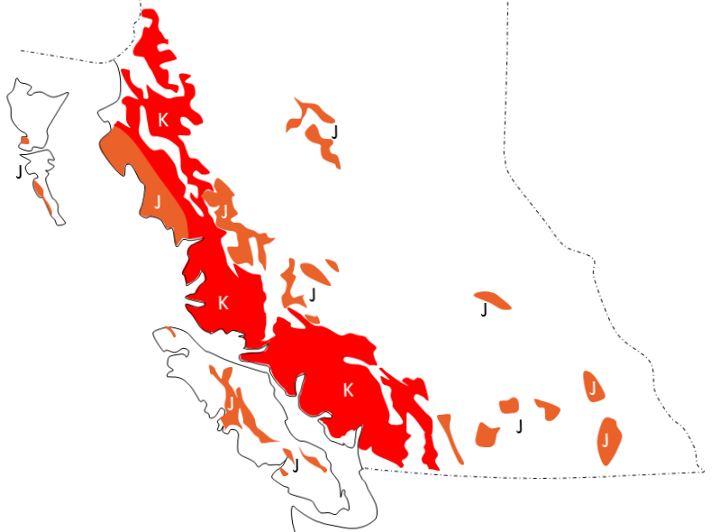
Figure 21.4.8 image description: Cretaceous rocks cover a lot of the southwest coast of BC and a bit in the north. Jurassic rocks can be found on the northwest coast of BC, scattered sparsely through the interior, and a bit on Haida Gwaii, and Vancouver Island. [Return to Figure 21.4.8]
Figure 21.4.11 image description: At the Rocky Mountian foothills, the Paleozoic sedimentary rocks are buried over 4500 metres under Mesozoic sedimentary rocks. At the Alberta-Saskatchewan border, the Mesozoic layers are much thinner, so the Paleozoic sedimentary rocks are much nearer to the surface. [Return to Figure 21.4.11]
Media Attributions
- Figure 21.4.1: © Steven Earle. CC BY.
- Figure 21.4.2: © Steven Earle. CC BY. After Yukon and BC Geological Surveys.
- Figure 21.4.3, 21.4.4: © Steven Earle. CC BY.
- Figure 21.4.5: “Mt Rae Alberta Canada aerial1” by Kevin lenz. CC BY-SA.
- Figure 21.4.6, 21.4.7, 21.4.8: © Steven Earle. CC BY.
- Figure 21.4.9: © Isaac Earle. CC BY.
- Figure 21.4.10: © Steven Earle. CC BY. After the Alberta Geological Survey.
- Figure 21.4.11: © Steven Earle. CC BY. After the Alberta Geological Survey.
- Figure 21.4.12: © Steven Earle. CC BY.
- Figure 21.4.13: “Dinosaur park formation fauna” by J.T. Csotonyi. CC BY-SA.
- Figure 21.4.14: © Steven Earle. CC BY.
the process by which continental blocks (terranes) are added to existing continental areas
