9.4 Depositional Environments and Sedimentary Basins
The setting in which sediments are accumulated is called a depositional environment. (Some of the more important of these environments are illustrated in Figure 9.19.) Thus far you’ve seen that some types of sedimentary rocks—coal, and gypsum, for example—require very specific conditions to form because particular biological processes or chemical reactions are necessary. Different types of clastic sedimentary rocks also form in particular depositional environments. In the case of clastic rocks, the key environmental conditions are related to the amount of energy available to transport sediments, and how far the sediments get from their source before being deposited.
Broadly, depositional environments can be said to be terrestrial, marine, or to reflect a transitional zone between the two. Terrestrial refers to depositional environments on land. These may be depositional environments such as deserts, found on dry land, but they could also be environments such as freshwater lakes or rivers. Marine refers to environments associated with saltwater seas and oceans. Transitional depositional environments include environments such as deltas, where freshwater rivers empty into saltwater seas or oceans.
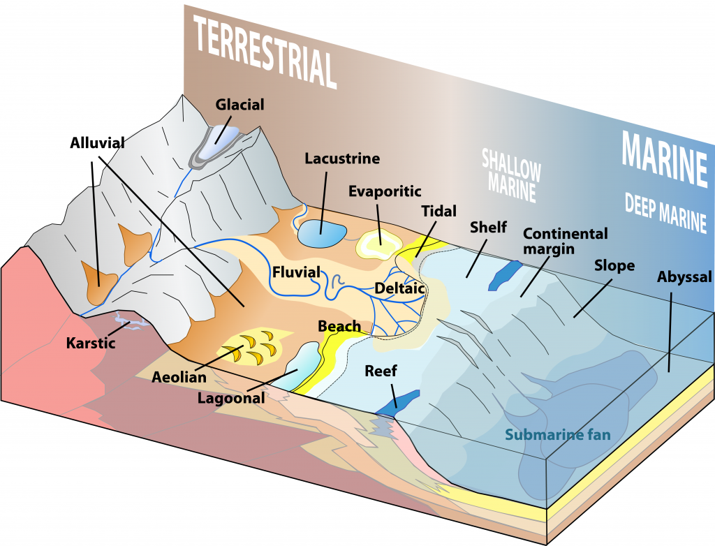
Tables 9.1 and 9.2 provide a summary of the processes and sediment types that pertain to the various depositional environments illustrated in Figure 9.19. The types of sediments that accumulate in these environments are examined in more detail in the last section of this chapter.
| Environment | Key Transport Processes | Depositional Settings | Typical Sediments |
|---|---|---|---|
| Glacial | Gravity, moving ice, moving water | Valleys, plains, streams, lakes | Glacial till, gravel, sand, silt, clay |
| Alluvial | Gravity, moving water | Where steep-sided valleys meet plains | Coarse angular fragments |
| Fluvial | Moving water | Streams | Gravel, sand, silt, organic matter |
| Aeolian | Wind | Deserts and coastal regions | Sand, silt |
| Lacustrine | Moving Water | Lakes | Sand, silt, clay, organic matter |
| Evaporite | Still water | Lakes in arid regions | Salts, clay |
| Environment | Key Transport Processes | Depositional Settings | Typical Sediments |
|---|---|---|---|
| Deltaic | Moving water | Deltas | Sand, silt, clay, organic matter |
| Beach | Waves, long-shore currents | Beaches, spits, sand bars | Gravel, sand |
| Tidal | Tidal currents | Tidal flats | Fine-grained sand, silt, clay |
| Reef | Waves, tidal currents | Reefs and adjacent basins | Carbonates |
| Shallow marine | Waves, tidal currents | Shelves, slopes, lagoons | Carbonates in tropical climates; sand/silt/clay elsewhere. |
| Lagoonal | Little transportation | Lagoon bottom | Carbonates in tropical climates, silt, clay |
| Submarine fan | Underwater gravity flows | Continental slopes, abyssal plains | Gravel, sand, silt, clay |
| Deep water | Ocean currents | Deep-ocean abyssal plains | Clay, carbonate mud, silica mud |
Sedimentary Basins Are Needed to Collect Sediment
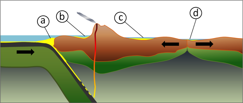
Most of the sediments that you might see around you, including talus on steep slopes, sand bars in streams, or gravel in road cuts, will never become sedimentary rocks. This is because they’ve only been deposited relatively recently—perhaps a few centuries or millennia ago—and will be re-eroded before they are buried deep enough beneath other sediments to be lithified. In order for sediments to be preserved long enough to be turned into rock (a process that takes millions or tens of millions of years) they need to have been deposited in a basin in which sediments can be preserved for that long. Most such basins are formed by plate tectonic processes (Figure 9.20).

Trench basins form where a subducting oceanic plate dips beneath the overriding continental or oceanic lithosphere. They can be several kilometres deep, and in many cases, host thick sequences of sediments from nearby eroding coastal mountains. There is a well-developed trench basin off the west coast of Vancouver Island.
A forearc basin lies between the subduction zone and the volcanic arc, and may be formed in part by friction between the subducting plate and the overriding plate, which pulls part of the overriding plate down. The Strait of Georgia, the channel between Vancouver Island and the BC mainland, is a forearc basin.
A foreland basin is caused by the mass of a mountain range depressing the crust. A rift basin forms where continental crust is being pulled apart, and the crust on both sides the rift subsides. If rifting continues this will eventually becomes a narrow sea, and then an ocean basin. The East African rift basin represents an early stage in this process.
Practice with Types of Sedimentary Basins
One type of sedimentary basin forms when continental crust begins to split apart and sag downward. This is a basin.
Other types of sedimentary basins are related to subduction zones. The deepest type, a basin, occurs right where subduction is happening.
If a subducting plate drags down the front edge of the plate with which it’s colliding, a basin could form between the subduction zone and a chain of volcanic mountains.
Thanks to isostasy, the weight of the mountains themselves can flex the lithosphere downward into a basin.
To check your answers, navigate to the below link to view the interactive version of this activity.
