19.5 Other Dating Methods
There are numerous other techniques for dating geological materials, but we will examine just two of them here: dendrochronology—tree-ring dating—and dating based on the record of reversals of Earth’s magnetic field.
Dendrochronology
Dendrochronology can be applied to dating very young geological materials based on reference records of tree-ring growth going back many millennia. The longest such records can take us back over 25 ka, to the height of the last glaciation. One of the advantages of dendrochronology is that, providing reliable reference records are available, the technique can be used to date events to the nearest year.
Dendrochronology has been used to date the last major subduction zone earthquake on the coast of B.C., Washington, and Oregon. When large earthquakes occur in this region, there’s a tendency for some coastal areas to subside by one or two metres. Seawater then rushes in, flooding coastal flats and killing trees and other vegetation within a few months. There are at least four locations along the coast of Washington that have such dead trees, and probably many more in other areas. Wood samples from these trees have been studied and the ring patterns have been compared with patterns from old living trees in the region (Figure 19.19).
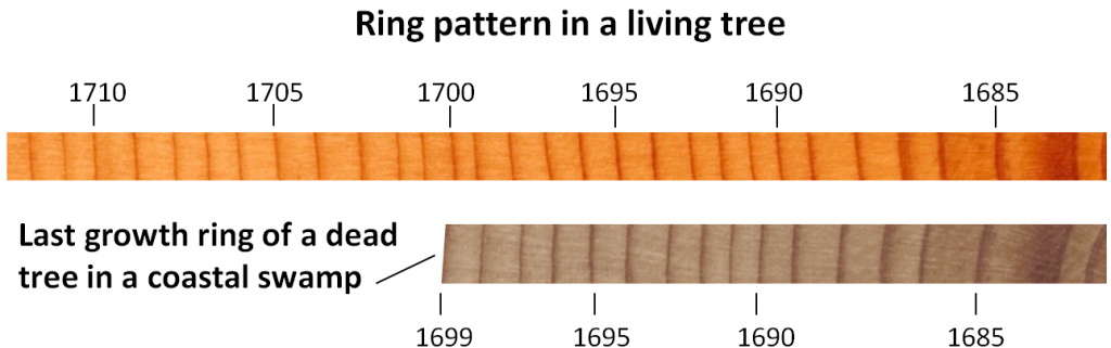
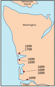
At all of the locations studied, the trees were found to have died either in the year 1699, or very shortly thereafter (Figure 19.20). This led to the conclusion that a major earthquake took place in this region sometime between the end of growing season in 1699 and the beginning of the growing season in 1700. Evidence from a major tsunami that struck Japan on January 27, 1700, narrowed the timing of the earthquake to sometime in the evening of January 26, 1700. (For more information, see The 1700 Juan de Fuca Earthquake – Steven Earle – Malaspina University-College.)
Magnetic Chronology
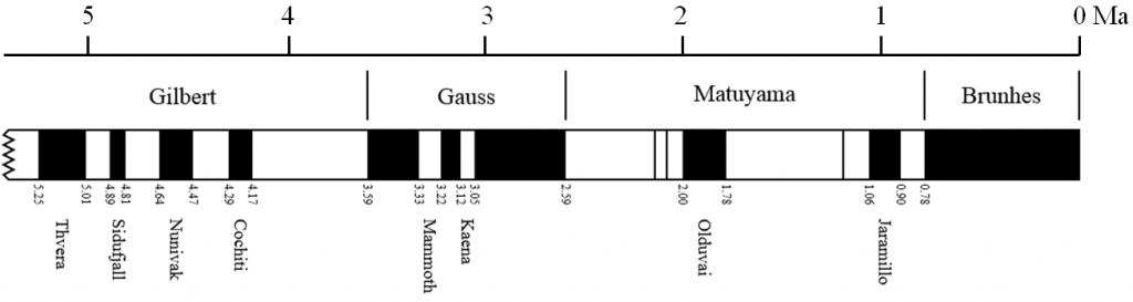
Changes in Earth’s magnetic field can also be used to date events in geologic history. The magnetic field causes compass needles point toward the north magnetic pole, but this hasn’t always been the case. At various times in the past, Earth’s magnetic field has reversed its polarity, and during such times a compass needle would have pointed to the south magnetic pole. By studying magnetism in volcanic rocks that have been dated isotopically, geologists have been able to establish the chronology of magnetic field reversals going back for ~250 Ma.
About 5 Ma of this record is shown in Figure 19.21, where the black bands represent periods of normal magnetism (“normal” meaning a polarity identical to the current magnetic field) and the white bands represent periods of reversed magnetic polarity. These periods of consistent magnetic polarity are given names to make them easier to reference. The current period of normal magnetic polarity, known as Brunhes, has lasted for the past 780,000 years. Prior to that there was a short reversed period and then a short normal period, the latter of which is known as Jaramillo.
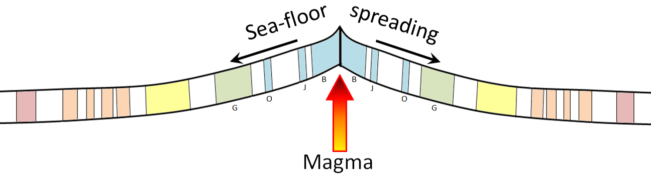
Oceanic crust becomes magnetized by the magnetic field that exists as the crust forms from magma at mid-ocean ridges. As magma cools, the magnetic fields of tiny crystals of magnetite that form within the magma become aligned with the existing magnetic field, and remain in this orientation, even if Earth’s magnetic field later changes polarity (Figure 19.22). Oceanic crust that is forming today is being magnetized in a “normal” sense, but crust that formed 780,000 to 900,000 years ago, in the interval between the Brunhes and Jaramillo normal periods, was magnetized in the “reversed” sense.
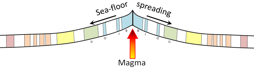
Magnetic chronology can be used as a dating technique because we can measure the magnetic field of rocks using a magnetometer, or of entire regions by towing a magnetometer behind a ship or an airplane. For example, the Juan de Fuca Plate, which lies off of the west coast of BC, Washington, and Oregon, is being and has been formed along the Juan de Fuca spreading ridge (Figure 19.23). The parts of the plate that are still close to the ridge exhibit normal magnetic polarity, while parts that are further away (and formed much earlier) have either normal or reversed magnetic polarity, depending upon when the rock formed.
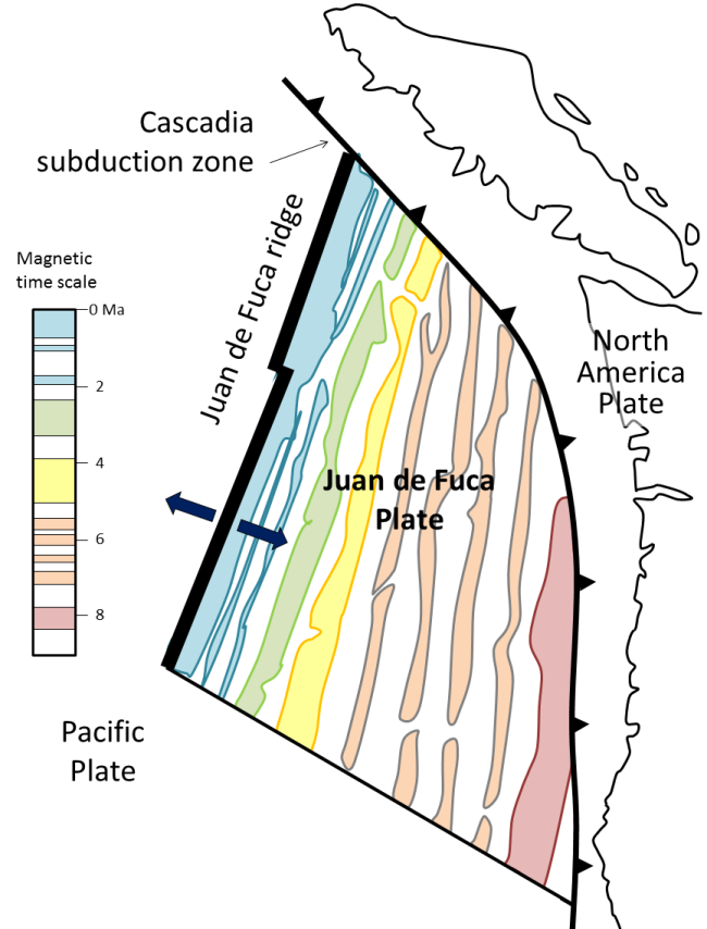
By carefully matching the sea-floor magnetic stripes with the known magnetic chronology, we can determine the age at any point on the plate. We can see that the oldest part of the Juan de Fuca Plate that has not yet subducted (off of the coast of Oregon) is just over 8 million years old, while the part that is subducting beneath Vancouver Island is between 0 and ~6 million years old.
Putting It Together: Using Fossils with Magnetic Polarity to Date Rocks
References
Yamaguchi, D.K., Atwater, B.F., Bunker, D.E., Benson, B.E., & Reid, M. S. (1997). Tree-ring dating the 1700 Cascadia earthquake. Nature, 389, 922-923.
