12.5 Forecasting Earthquakes and Minimizing Impacts
It has long been a dream of seismologists, geologists, and public safety officials to be able to accurately predict the location, magnitude, and timing of earthquakes on time scales that would be useful for minimizing danger to the public and damage to infrastructure (e.g., weeks, days, hours). Many methods of prediction that have been explored. These include using observations of warning foreshocks, changes in magnetic fields, episodic tremor and slip, changing groundwater levels, strange animal behaviour, patterns in the timing between earthquakes, and how stress is transferred after a rupture. So far, none of these has provided a reliable method. Although there are some reports of successful earthquake predictions, they are rare, and many are surrounded by doubtful circumstances.
The Parkfield Prediction Experiment
There was great hope for earthquake predictions late in the 1980s when attention was focused on part of the San Andreas Fault at Parkfield, approximately 200 km south of San Francisco, California. Between 1881 and 1965 there were five earthquakes at Parkfield. They were spaced at approximately 20-year intervals, all confined to the same 20 km-long segment of the fault, and all very close to M6 (Figure 12.33). Both the 1934 and 1966 earthquakes were preceded by small foreshocks exactly 17 minutes before the main quake.
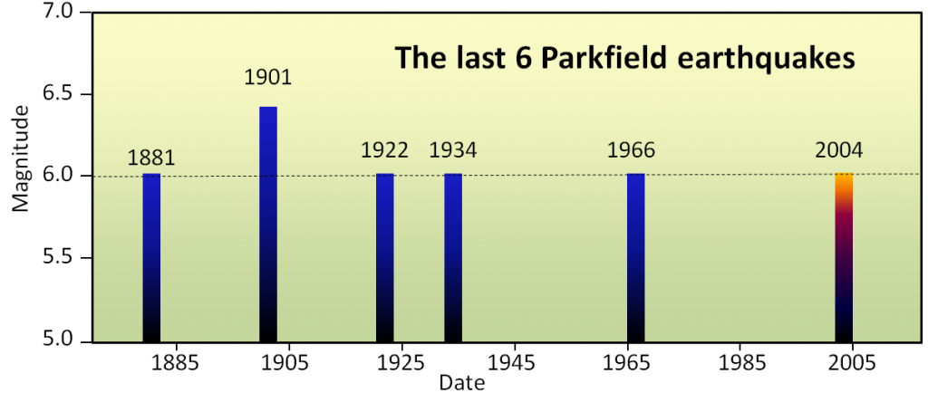
The U. S. Geological Survey recognized this as an excellent opportunity to understand earthquakes and earthquake prediction, so they armed the Parkfield area with a huge array of geophysical instruments and waited. The next earthquake was expected to happen around 1987, but nothing happened! The “1987 Parkfield earthquake” finally struck in September 2004. Fortunately, all of the equipment was still there to record the earthquake, but it was no help from the perspective of earthquake prediction. There were no significant precursors to the 2004 Parkfield earthquake in any of the parameters measured, including tremors, changes in rock deformation, the magnetic field, the electrical conductivity of the rock, and creep (motion along the fault that is not accompanied by earthquakes). There was no foreshock. In other words, even though every available technique was used to monitor it, the 2004 earthquake came with no warning whatsoever.
Earthquake Probabilities
To be useful to the public and governments, earthquake predictions must be accurate most of the time, not just some of the time. If a prediction method is only accurate 10% of the time (and even that isn’t possible with the current state of knowledge), the public will lose faith in the process very quickly, and then will ignore all of the predictions. The hope for earthquake prediction is not dead, but it was hit hard by the Parkfield experiment.
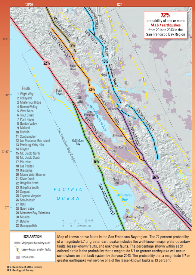
Today the focus of efforts in earthquake-prone regions is to provide forecasts of earthquake probability. Earthquake probabilities express the likelihood that an earthquake of a given magnitude will occur at a location within a given period of time. An example of this approach for the San Francisco Bay region of California is shown in Figure 12.34. Based on a wide range of information, including past earthquake history, accumulated stress from plate movement, and known stress transfer, seismologists and geologists have predicted the likelihood of a M6.7 or greater earthquake on each of eight major faults that cut through the region. The greatest probabilities are on the San Andreas, Rogers Creek/Hayward faults, and Calaveras/Paicines faults. There is a 72% chance that a major and damaging earthquake will take place somewhere in the region prior to 2043.
Using Earthquake Probability Information
Decision makers can use forecasts of earthquake probability to assist with educating the public about earthquake risks, and to determine what action is necessary to make infrastructure earthquake-safe. Building safe infrastructure requires strong building codes, and enforcement of those codes. Building code compliance is robust in most developed countries, but is inadequate in many developing countries.
New buildings are not the only ones requiring attention. Existing buildings — especially schools and hospitals — and other structures such as bridges and dams, must also be made safe. British Columbia began a multi-billion-dollar program in 2004 to make public schools safer for students. The program is focused on older public schools, because, according to the government, those built since 1992 already comply with modern seismic codes. Some schools would require too much work to make upgrading economically feasible and they are replaced. Where upgrading is feasible, the school is assessed carefully before any upgrade work is initiated. The seismic mitigation program identified 346 schools as being at high risk and in need of upgrades. As of December 2017, upgrades were completed at 168 schools, 28 schools were under construction or had approval to proceed with construction, and 150 did not yet have plans in place for upgrades.
The program in British Columbia illustrates a challenge with seismic upgrades of public buildings, which is that governments must make adequate funds available for the upgrades to be done in a timely manner. The priority allocated to funding those projects will depend on how urgent the need for upgrades is considered to be, given other demands on public funds.
Earthquake Preparedness
Earthquake preparedness involves the formulation of public emergency plans, including escape routes, medical facilities, shelters, and food and water supplies. It also includes personal planning, such as emergency supplies (food, water, shelter, and warmth), escape routes from houses and offices, and communication strategies (with a focus on ones that don’t involve the cellular network).
References
Finn, W. D. L., & Dexter, A. (2012). Risk management plan for school seismic mitigation program. https://www2.gov.bc.ca/assets/gov/education/administration/resource-management/capital-planning/risk_management_plan_school_seismic_mitigation_program_2012.pdf
Province of British Columbia (n.d.). Seismic mitigation program. https://www2.gov.bc.ca/gov/content/education-training/administration/resource-management/capital-planning/seismic-mitigation-program
Province of British Columbia (2017). Seismic mitigation program progress report. https://www2.gov.bc.ca/assets/gov/education/administration/resource-management/capital-planning/seismic-mitigation/progress_report.pdf
